Chapeltique geodata
Chapeltique (San Miguel) is a populated place; located in El Salvador in America/El_Salvador (GMT-6) time zone. With population of 3,159 people, there are 78 cities with bigger population in this country. Compared to other cities in El Salvador, 64% of cities are located further ↑North; 81% of cities are located further ←West and 81% of cities have higher elevation than Chapeltique. Note1


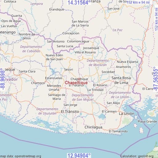
Chapeltique GPS coordinates[2]
13° 37' 59.988" North, 88° 16' 0.012" West
| Map corner | latitude | longitude |
|---|---|---|
| Upper-left | 14.31564°, | -88.9698° |
| Center: | 13.63333°, | -88.26667° |
| Lower-right: | 12.94904°, | -87.56355° |
| Map W x H: | 152×152 km | = 94.4×94.4mi |
| max Lat: | 14.33333° ⇑64% North |
| Chapeltique: | 13.63333° |
| min Lat: | ⇓36% South 13.19694° |
| min Long | Chapeltique | max Long |
| -90.01583° | -88.26667° | -87.83861° |
| W 81%⇐ | ⇒19% E |
Elevation
Elevation of Chapeltique is 186 m = 610 ft, and this is 285.9 m = 938 ft below average elevation for this country.
| Max E: |
1255 m = 4117 ft | 81% |
| Avg. | 471.9 m = 1548 ft | |
| Chapeltique | 186 m = 610 ft | |
Min E: |
13 m = 43 ft | 19% |
See also: El Salvador elevation on elevation.city.
Geographical zone
Chapeltique is located in North Torrid zone (between Equator and Tropic of Cancer). Distance of this Northern Tropic circle is 1090 km =677.3 mi to North.| Distance of | km | miles | from Chapeltique |
|---|---|---|---|
| North Pole | 8491.2 | 5276.2 | to North |
| Arctic Circle | 5885.3 | 3657 | to North |
| Tropic Cancer | 1090 | 677.3 | to North |
| Equator | 1515.9 | 941.9 | to South |


Nearby cities:
15 places around Chapeltique: (largest is in red/bold)
• Cacaopera
24.7 km =15.3 mi,  53°
53°
• Chinameca
17.3 km =10.7 mi,  211°
211°
• Ciudad Barrios
14.8 km =9.2 mi,  0°
0°
• Guatajiagua
8.1 km =5 mi,  62°
62°
• Jocoro
27.1 km =16.8 mi,  93°
93°
• Jucuapa
18.1 km =11.2 mi,  224°
224°
• Lolotique
12.9 km =8 mi, 224°
• Moncagua
11.3 km =7 mi,  170°
170°
• Nueva Guadalupe
14.3 km =8.9 mi, 219°
• San Francisco
19.5 km =12.1 mi,  67°
67°
• San Miguel
19 km =11.8 mi,  151°
151°
• San Rafael Oriente
29.2 km =18.1 mi,  197°
197°
• Santiago de María
27.3 km =17 mi,  232°
232°
• Sesori
14.2 km =8.8 mi,  310°
310°
• Sociedad
28 km =17.4 mi, 74°
Sources, notices
• [Note1] Compared only with cities in El Salvador existing in our database
• [Src1] Map data: © OpenStreetMap contributors (CC-BY-SA)
• [Src2] Other city data from geonames.org with taken over terms of usage.
• [Src3] Geographical zone / Annual Mean Temperature by Robert A. Rohde @ Wikipedia
