Guatajiagua geodata
Guatajiagua (Morazán) is a populated place; located in El Salvador in America/El_Salvador (GMT-6) time zone. With population of 5,273 people, there are 69 cities with bigger population in this country. Compared to other cities in El Salvador, 58% of cities are located further ↑North; 85% of cities are located further ←West and 67% of cities have higher elevation than Guatajiagua. Note1


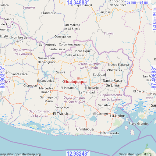
Guatajiagua GPS coordinates[2]
13° 40' 0.012" North, 88° 12' 0" West
| Map corner | latitude | longitude |
|---|---|---|
| Upper-left | 14.34888°, | -88.90313° |
| Center: | 13.66667°, | -88.2° |
| Lower-right: | 12.98248°, | -87.49688° |
| Map W x H: | 151.9×151.9 km | = 94.4×94.4mi |
| max Lat: | 14.33333° ⇑58% North |
| Guatajiagua: | 13.66667° |
| min Lat: | ⇓42% South 13.19694° |
| min Long | Guatajiagua | max Long |
| -90.01583° | -88.2° | -87.83861° |
| W 85%⇐ | ⇒15% E |
Elevation
Elevation of Guatajiagua is 288 m = 945 ft, and this is 183.9 m = 603 ft below average elevation for this country.
| Max E: |
1255 m = 4117 ft | 67% |
| Avg. | 471.9 m = 1548 ft | |
| Guatajiagua | 288 m = 945 ft | |
Min E: |
13 m = 43 ft | 33% |
See also: El Salvador elevation on elevation.city.
Geographical zone
Guatajiagua is located in North Torrid zone (between Equator and Tropic of Cancer). Distance of this Northern Tropic circle is 1086.3 km =675 mi to North.| Distance of | km | miles | from Guatajiagua |
|---|---|---|---|
| North Pole | 8487.5 | 5273.9 | to North |
| Arctic Circle | 5881.6 | 3654.7 | to North |
| Tropic Cancer | 1086.3 | 675 | to North |
| Equator | 1519.6 | 944.2 | to South |


Nearby cities:
15 places around Guatajiagua: (largest is in red/bold)
• Cacaopera
16.8 km =10.4 mi,  48°
48°
• Chapeltique
8.1 km =5 mi,  242°
242°
• Chinameca
24.6 km =15.3 mi,  221°
221°
• Ciudad Barrios
13.2 km =8.2 mi,  327°
327°
• Corinto
29.4 km =18.3 mi,  57°
57°
• Jocoro
20.6 km =12.8 mi,  105°
105°
• Jucuapa
25.9 km =16.1 mi,  229°
229°
• Lolotique
20.8 km =12.9 mi, 231°
• Moncagua
15.8 km =9.8 mi,  200°
200°
• Nueva Guadalupe
22 km =13.7 mi, 227°
• San Francisco
11.4 km =7.1 mi,  71°
71°
• San Miguel
20.5 km =12.7 mi,  174°
174°
• Santa Rosa de Lima
33.4 km =20.8 mi,  98°
98°
• Sesori
18.8 km =11.7 mi,  287°
287°
• Sociedad
20.1 km =12.5 mi,  79°
79°
Sources, notices
• [Note1] Compared only with cities in El Salvador existing in our database
• [Src1] Map data: © OpenStreetMap contributors (CC-BY-SA)
• [Src2] Other city data from geonames.org with taken over terms of usage.
• [Src3] Geographical zone / Annual Mean Temperature by Robert A. Rohde @ Wikipedia
