Zaragoza geodata
Zaragoza (La Libertad) is a populated place; located in El Salvador in America/El_Salvador (GMT-6) time zone. With population of 11,749 people, there are 38 cities with bigger population in this country. Compared to other cities in El Salvador, 69% of cities are located further ↑North; 73% of cities are located further →East and 62% of cities have lower elevation than Zaragoza. Note1


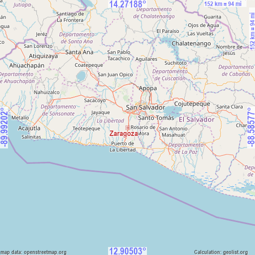
Zaragoza GPS coordinates[2]
13° 35' 21.984" North, 89° 17' 20.004" West
| Map corner | latitude | longitude |
|---|---|---|
| Upper-left | 14.27188°, | -89.99202° |
| Center: | 13.58944°, | -89.28889° |
| Lower-right: | 12.90503°, | -88.58577° |
| Map W x H: | 152×152 km | = 94.4×94.4mi |
| max Lat: | 14.33333° ⇑69% North |
| Zaragoza: | 13.58944° |
| min Lat: | ⇓31% South 13.19694° |
| min Long | Zaragoza | max Long |
| -90.01583° | -89.28889° | -87.83861° |
| W 27%⇐ | ⇒73% E |
Elevation
Elevation of Zaragoza is 612 m = 2008 ft, and this is 140.1 m = 460 ft above average elevation for this country.
| Max E: |
1255 m = 4117 ft | 38% |
| Zaragoza | 612 m 2008 ft | |
| Avg. | 471.9 m = 1548 ft | |
Min E: |
13 m = 43 ft | 62% |
See also: El Salvador elevation on elevation.city.
Geographical zone
Zaragoza is located in North Torrid zone (between Equator and Tropic of Cancer). Distance of this Northern Tropic circle is 1094.9 km =680.3 mi to North.| Distance of | km | miles | from Zaragoza |
|---|---|---|---|
| North Pole | 8496.1 | 5279.2 | to North |
| Arctic Circle | 5890.2 | 3660 | to North |
| Tropic Cancer | 1094.9 | 680.3 | to North |
| Equator | 1511 | 938.9 | to South |


Nearby cities:
15 places around Zaragoza: (largest is in red/bold)
• Antiguo Cuscatlán
9.2 km =5.7 mi,  24°
24°
• Ayutuxtepeque
19.5 km =12.1 mi,  27°
27°
• Cuscatancingo
20 km =12.4 mi,  35°
35°
• Delgado
19.7 km =12.2 mi, 40°
• La Libertad
11.8 km =7.3 mi,  197°
197°
• Mejicanos
18.7 km =11.6 mi, 26°
• Nuevo Cuscatlán
7.1 km =4.4 mi, 21°
• Olocuilta
18.7 km =11.6 mi,  96°
96°
• Panchimalco
12.1 km =7.5 mi,  77°
77°
• Rosario de Mora
8.8 km =5.5 mi, 100°
• San Marcos
13.8 km =8.6 mi,  55°
55°
• San Salvador
15.6 km =9.7 mi, 44°
• Santa Tecla
9.8 km =6.1 mi,  5°
5°
• Santo Tomás
17.8 km =11.1 mi,  71°
71°
• Soyapango
21 km =13 mi,  50°
50°
Sources, notices
• [Note1] Compared only with cities in El Salvador existing in our database
• [Src1] Map data: © OpenStreetMap contributors (CC-BY-SA)
• [Src2] Other city data from geonames.org with taken over terms of usage.
• [Src3] Geographical zone / Annual Mean Temperature by Robert A. Rohde @ Wikipedia
