Sesori geodata
Sesori (San Miguel) is a populated place; located in El Salvador in America/El_Salvador (GMT-6) time zone. With population of 1,390 people, there are 97 cities with bigger population in this country. Compared to other cities in El Salvador, 51% of cities are located further ↓South; 74% of cities are located further ←West and 82% of cities have higher elevation than Sesori. Note1


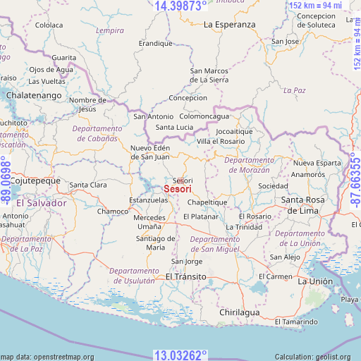
Sesori GPS coordinates[2]
13° 43' 0.012" North, 88° 22' 0.012" West
| Map corner | latitude | longitude |
|---|---|---|
| Upper-left | 14.39873°, | -89.0698° |
| Center: | 13.71667°, | -88.36667° |
| Lower-right: | 13.03262°, | -87.66355° |
| Map W x H: | 151.9×151.9 km | = 94.4×94.4mi |
| max Lat: | 14.33333° ⇑49% North |
| Sesori: | 13.71667° |
| min Lat: | ⇓51% South 13.19694° |
| min Long | Sesori | max Long |
| -90.01583° | -88.36667° | -87.83861° |
| W 74%⇐ | ⇒26% E |
Elevation
Elevation of Sesori is 184 m = 604 ft, and this is 287.9 m = 945 ft below average elevation for this country.
| Max E: |
1255 m = 4117 ft | 82% |
| Avg. | 471.9 m = 1548 ft | |
| Sesori | 184 m = 604 ft | |
Min E: |
13 m = 43 ft | 18% |
See also: El Salvador elevation on elevation.city.
Geographical zone
Sesori is located in North Torrid zone (between Equator and Tropic of Cancer). Distance of this Northern Tropic circle is 1080.8 km =671.6 mi to North.| Distance of | km | miles | from Sesori |
|---|---|---|---|
| North Pole | 8481.9 | 5270.4 | to North |
| Arctic Circle | 5876 | 3651.2 | to North |
| Tropic Cancer | 1080.8 | 671.6 | to North |
| Equator | 1525.2 | 947.7 | to South |


Nearby cities:
15 places around Sesori: (largest is in red/bold)
• Berlín
30.1 km =18.7 mi,  216°
216°
• Cacaopera
31.1 km =19.3 mi,  79°
79°
• Chapeltique
14.2 km =8.8 mi,  130°
130°
• Chinameca
24.2 km =15 mi,  175°
175°
• Ciudad Barrios
12.1 km =7.5 mi,  62°
62°
• Guatajiagua
18.8 km =11.7 mi,  107°
107°
• Jucuapa
22.3 km =13.9 mi, 184°
• Lolotique
18.6 km =11.6 mi,  174°
174°
• Moncagua
24 km =14.9 mi,  148°
148°
• Nueva Guadalupe
20.5 km =12.7 mi, 174°
• San Francisco
28.9 km =18 mi,  93°
93°
• San Miguel
32.6 km =20.3 mi,  142°
142°
• San Rafael Oriente
37.1 km =23.1 mi, 177°
• Santiago de María
28.1 km =17.5 mi,  202°
202°
• Sensuntepeque
33.3 km =20.7 mi,  300°
300°
Sources, notices
• [Note1] Compared only with cities in El Salvador existing in our database
• [Src1] Map data: © OpenStreetMap contributors (CC-BY-SA)
• [Src2] Other city data from geonames.org with taken over terms of usage.
• [Src3] Geographical zone / Annual Mean Temperature by Robert A. Rohde @ Wikipedia
