La Libertad geodata
La Libertad is a populated place; located in El Salvador in America/El_Salvador (GMT-6) time zone. With population of 16,855 people, there are 31 cities with bigger population in this country. Compared to other cities in El Salvador, 83% of cities are located further ↑North; 75% of cities are located further →East and 100% of cities have higher elevation than La Libertad. Note1


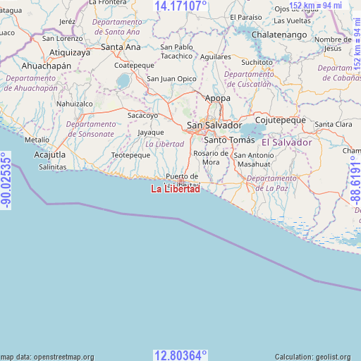
La Libertad GPS coordinates[2]
13° 29' 17.988" North, 89° 19' 19.992" West
| Map corner | latitude | longitude |
|---|---|---|
| Upper-left | 14.17107°, | -90.02535° |
| Center: | 13.48833°, | -89.32222° |
| Lower-right: | 12.80364°, | -88.6191° |
| Map W x H: | 152×152 km | = 94.4×94.4mi |
| max Lat: | 14.33333° ⇑83% North |
| La Libertad: | 13.48833° |
| min Lat: | ⇓17% South 13.19694° |
| min Long | La Libertad | max Long |
| -90.01583° | -89.32222° | -87.83861° |
| W 25%⇐ | ⇒75% E |
Elevation
Elevation of La Libertad is 13 m = 43 ft, and this is 458.9 m = 1506 ft below average elevation for this country.
| Max E: |
1255 m = 4117 ft | 100% |
| Avg. | 471.9 m = 1548 ft | |
| La Libertad | 13 m = 43 ft | |
Min E: |
13 m = 43 ft | 0% |
See also: El Salvador elevation on elevation.city.
Geographical zone
La Libertad is located in North Torrid zone (between Equator and Tropic of Cancer). Distance of this Northern Tropic circle is 1106.2 km =687.4 mi to North.| Distance of | km | miles | from La Libertad |
|---|---|---|---|
| North Pole | 8507.3 | 5286.2 | to North |
| Arctic Circle | 5901.4 | 3667 | to North |
| Tropic Cancer | 1106.2 | 687.4 | to North |
| Equator | 1499.8 | 931.9 | to South |


Nearby cities:
15 places around La Libertad: (largest is in red/bold)
• Antiguo Cuscatlán
21 km =13 mi,  20°
20°
• Ayutuxtepeque
31.2 km =19.4 mi, 23°
• Cuscatancingo
31.5 km =19.6 mi,  28°
28°
• Delgado
30.9 km =19.2 mi, 32°
• Mejicanos
30.4 km =18.9 mi, 22°
• Nuevo Cuscatlán
18.9 km =11.7 mi, 19°
• Olocuilta
23.9 km =14.9 mi,  67°
67°
• Panchimalco
20.7 km =12.9 mi,  48°
48°
• Rosario de Mora
15.6 km =9.7 mi, 51°
• San Marcos
24.2 km =15 mi,  38°
38°
• San Pedro Masahuat
31.3 km =19.4 mi,  78°
78°
• San Salvador
26.7 km =16.6 mi, 33°
• Santa Tecla
21.5 km =13.4 mi,  12°
12°
• Santo Tomás
26.5 km =16.5 mi, 50°
• Zaragoza
11.8 km =7.3 mi, 17°
Sources, notices
• [Note1] Compared only with cities in El Salvador existing in our database
• [Src1] Map data: © OpenStreetMap contributors (CC-BY-SA)
• [Src2] Other city data from geonames.org with taken over terms of usage.
• [Src3] Geographical zone / Annual Mean Temperature by Robert A. Rohde @ Wikipedia
