Izalco geodata
Izalco (Sonsonate) is a populated place; located in El Salvador in America/El_Salvador (GMT-6) time zone. With population of 19,197 people, there are 27 cities with bigger population in this country. Compared to other cities in El Salvador, 61% of cities are located further ↓South; 86% of cities are located further →East and 56% of cities have higher elevation than Izalco. Note1


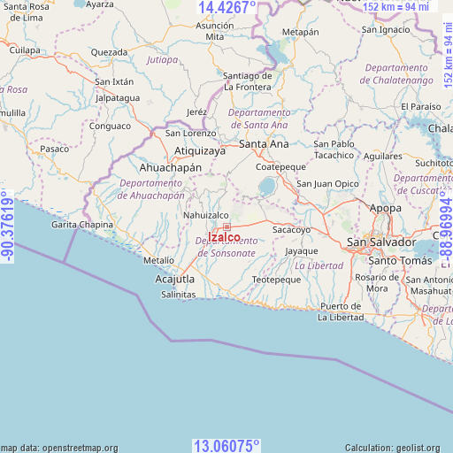
Izalco GPS coordinates[2]
13° 44' 40.992" North, 89° 40' 23.016" West
| Map corner | latitude | longitude |
|---|---|---|
| Upper-left | 14.4267°, | -90.37619° |
| Center: | 13.74472°, | -89.67306° |
| Lower-right: | 13.06075°, | -88.96994° |
| Map W x H: | 151.9×151.9 km | = 94.4×94.4mi |
| max Lat: | 14.33333° ⇑39% North |
| Izalco: | 13.74472° |
| min Lat: | ⇓61% South 13.19694° |
| min Long | Izalco | max Long |
| -90.01583° | -89.67306° | -87.83861° |
| W 14%⇐ | ⇒86% E |
Elevation
Elevation of Izalco is 422 m = 1385 ft, and this is 49.9 m = 164 ft below average elevation for this country.
| Max E: |
1255 m = 4117 ft | 56% |
| Avg. | 471.9 m = 1548 ft | |
| Izalco | 422 m = 1385 ft | |
Min E: |
13 m = 43 ft | 44% |
See also: El Salvador elevation on elevation.city.
Geographical zone
Izalco is located in North Torrid zone (between Equator and Tropic of Cancer). Distance of this Northern Tropic circle is 1077.6 km =669.6 mi to North.| Distance of | km | miles | from Izalco |
|---|---|---|---|
| North Pole | 8478.8 | 5268.5 | to North |
| Arctic Circle | 5872.9 | 3649.2 | to North |
| Tropic Cancer | 1077.6 | 669.6 | to North |
| Equator | 1528.3 | 949.6 | to South |


Nearby cities:
15 places around Izalco: (largest is in red/bold)
• Acajutla
23.7 km =14.7 mi,  224°
224°
• Ahuachapán
27 km =16.8 mi,  316°
316°
• Armenia
18.8 km =11.7 mi,  90°
90°
• Atiquizaya
27.2 km =16.9 mi,  341°
341°
• Chalchuapa
26.9 km =16.7 mi,  358°
358°
• Ciudad Arce
26.6 km =16.5 mi,  66°
66°
• Concepción de Ataco
23.5 km =14.6 mi,  306°
306°
• El Congo
26.4 km =16.4 mi,  46°
46°
• Guaymango
18.3 km =11.4 mi,  271°
271°
• Juayúa
13.3 km =8.3 mi, 323°
• Jujutla
20.4 km =12.7 mi,  283°
283°
• Nahuizalco
7.8 km =4.8 mi,  297°
297°
• San Antonio del Monte
7.7 km =4.8 mi,  245°
245°
• Sonsonate
6.2 km =3.9 mi,  242°
242°
• Sonzacate
4.7 km =2.9 mi,  255°
255°
Sources, notices
• [Note1] Compared only with cities in El Salvador existing in our database
• [Src1] Map data: © OpenStreetMap contributors (CC-BY-SA)
• [Src2] Other city data from geonames.org with taken over terms of usage.
• [Src3] Geographical zone / Annual Mean Temperature by Robert A. Rohde @ Wikipedia
