Juayúa geodata
Juayúa (Sonsonate) is a populated place; located in El Salvador in America/El_Salvador (GMT-6) time zone. With population of 9,936 people, there are 44 cities with bigger population in this country. Compared to other cities in El Salvador, 77% of cities are located further ↓South; 92% of cities are located further →East and 99% of cities have lower elevation than Juayúa. Note1


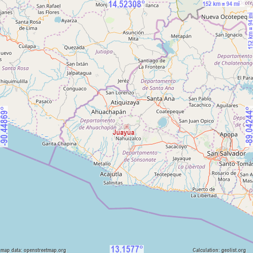
Juayúa GPS coordinates[2]
13° 50' 29.004" North, 89° 44' 44.016" West
| Map corner | latitude | longitude |
|---|---|---|
| Upper-left | 14.52308°, | -90.44869° |
| Center: | 13.84139°, | -89.74556° |
| Lower-right: | 13.1577°, | -89.04244° |
| Map W x H: | 151.8×151.8 km | = 94.3×94.3mi |
| max Lat: | 14.33333° ⇑23% North |
| Juayúa: | 13.84139° |
| min Lat: | ⇓77% South 13.19694° |
| min Long | Juayúa | max Long |
| -90.01583° | -89.74556° | -87.83861° |
| W 8%⇐ | ⇒92% E |
Elevation
Elevation of Juayúa is 1037 m = 3402 ft, and this is 565.1 m = 1854 ft above average elevation for this country.
| Max E: |
1255 m = 4117 ft | 1% |
| Juayúa | 1037 m 3402 ft | |
| Avg. | 471.9 m = 1548 ft | |
Min E: |
13 m = 43 ft | 99% |
See also: El Salvador elevation on elevation.city.
Geographical zone
Juayúa is located in North Torrid zone (between Equator and Tropic of Cancer). Distance of this Northern Tropic circle is 1066.9 km =662.9 mi to North.| Distance of | km | miles | from Juayúa |
|---|---|---|---|
| North Pole | 8468 | 5261.8 | to North |
| Arctic Circle | 5862.2 | 3642.6 | to North |
| Tropic Cancer | 1066.9 | 662.9 | to North |
| Equator | 1539 | 956.3 | to South |


Nearby cities:
15 places around Juayúa: (largest is in red/bold)
• Ahuachapán
13.9 km =8.6 mi,  309°
309°
• Atiquizaya
15.1 km =9.4 mi,  357°
357°
• Chalchuapa
17.6 km =10.9 mi,  23°
23°
• Coatepeque
27.8 km =17.3 mi,  69°
69°
• Concepción de Ataco
11.6 km =7.2 mi,  286°
286°
• El Congo
28 km =17.4 mi, 74°
• Guaymango
14.5 km =9 mi,  225°
225°
• Izalco
13.3 km =8.3 mi,  143°
143°
• Jujutla
13.5 km =8.4 mi,  243°
243°
• Nahuizalco
7.2 km =4.5 mi,  172°
172°
• San Antonio del Monte
13.9 km =8.6 mi,  176°
176°
• Santa Ana
26.3 km =16.3 mi,  49°
49°
• Sonsonate
13.8 km =8.6 mi, 170°
• Sonzacate
12.4 km =7.7 mi,  164°
164°
• Tacuba
21 km =13 mi, 288°
Sources, notices
• [Note1] Compared only with cities in El Salvador existing in our database
• [Src1] Map data: © OpenStreetMap contributors (CC-BY-SA)
• [Src2] Other city data from geonames.org with taken over terms of usage.
• [Src3] Geographical zone / Annual Mean Temperature by Robert A. Rohde @ Wikipedia
