Tall Salḩab geodata
Tall Salḩab (Hama) is a seat of a third-order administrative division; located in Syria in Asia/Damascus (GMT+3) time zone. In our database, there are 87 cities with bigger population. Compared to other cities in Syria, 53.4% of cities are located further ↓South; 63.6% of cities are located further →East and 89.8% of cities have higher elevation than Tall Salḩab. Note1


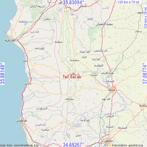
Tall Salḩab GPS coordinates[2]
35° 15' 31.824" North, 36° 23' 4.596" East
| Map corner | latitude | longitude |
|---|---|---|
| Upper-left | 35.83094°, | 35.68149° |
| Center: | 35.25884°, | 36.38461° |
| Lower-right: | 34.68267°, | 37.08774° |
| Map W x H: | 127.7×127.7 km | = 79.3×79.3mi |
| max Lat: | 37.17701° ⇑46.6% North |
| Tall Salḩab: | 35.25884° |
| min Lat: | ⇓53.4% South 32.39332° |
| min Long | Tall Salḩab | max Long |
| 35.75572° | 36.38461° | 42.14006° |
| W 36.4%⇐ | ⇒63.6% E |
Elevation
Elevation of Tall Salḩab is 196 m = 643 ft, and this is 333.1 m = 1093 ft below average elevation for this country.
| Max E: |
1640 m = 5381 ft | 89.8% |
| Avg. | 529.1 m = 1736 ft | |
| Tall Salḩab | 196 m = 643 ft | |
Min E: |
4 m = 13 ft | 10.2% |
See also: Syria elevation on elevation.city.
Geographical zone
Tall Salḩab is located in North temperate zone (between Tropic of Cancer and the Arctic Circle). Distance of this Northern Tropic circle is 1314.5 km =816.8 mi to South.| Distance of | km | miles | from Tall Salḩab |
|---|---|---|---|
| North Pole | 6086.6 | 3782 | to North |
| Arctic Circle | 3480.8 | 2162.9 | to North |
| Tropic Cancer | 1314.5 | 816.8 | to South |
| Equator | 3920.4 | 2436 | to South |


Nearby cities:
15 places around Tall Salḩab: (largest is in red/bold)
• Ad Dālīyah
22 km =13.7 mi,  263°
263°
• Al Qadmūs
27.1 km =16.8 mi,  228°
228°
• As Suqaylibīyah
12 km =7.5 mi,  3°
3°
• Aţ Ţawāḩīn
21.3 km =13.2 mi, 226°
• Bayt Yāshūţ
25.1 km =15.6 mi,  283°
283°
• Jubb Ramlah
6.9 km =4.3 mi,  142°
142°
• Kaff al-Jaa
25.1 km =15.6 mi,  220°
220°
• Kafr Zaytā
23.6 km =14.7 mi,  57°
57°
• Kurnāz
17.3 km =10.7 mi,  32°
32°
• Maşyāf
21.9 km =13.6 mi,  190°
190°
• Muḩradah
17.1 km =10.6 mi,  94°
94°
• Qal‘at al Maḑīq
17.3 km =10.7 mi, 1°
• Tremseh
10.9 km =6.8 mi,  82°
82°
• Ḩalfāyā
20.1 km =12.5 mi, 89°
• Ḩarf al Musaytirah
26.9 km =16.7 mi,  302°
302°
Sources, notices
• [Note1] Compared only with cities in Syria existing in our database
• [Src1] Map data: © OpenStreetMap contributors (CC-BY-SA)
• [Src2] Other city data from geonames.org with taken over terms of usage.
• [Src3] Geographical zone / Annual Mean Temperature by Robert A. Rohde @ Wikipedia
