Maşyāf geodata
Maşyāf (Hama) is a seat of a second-order administrative division; located in Syria in Asia/Damascus (GMT+3) time zone. With population of 32,262 people, there are 42 cities with bigger population in this country. Compared to other cities in Syria, 52.3% of cities are located further ↑North; 66.1% of cities are located further →East and 55.8% of cities have lower elevation than Maşyāf. Note1


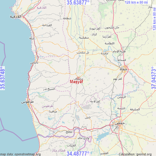
Maşyāf GPS coordinates[2]
35° 3' 55.08" North, 36° 20' 26.16" East
| Map corner | latitude | longitude |
|---|---|---|
| Upper-left | 35.63877°, | 35.63748° |
| Center: | 35.0653°, | 36.3406° |
| Lower-right: | 34.48777°, | 37.04373° |
| Map W x H: | 128×128 km | = 79.5×79.5mi |
| max Lat: | 37.17701° ⇑52.3% North |
| Maşyāf: | 35.0653° |
| min Lat: | ⇓47.7% South 32.39332° |
| min Long | Maşyāf | max Long |
| 35.75572° | 36.3406° | 42.14006° |
| W 33.9%⇐ | ⇒66.1% E |
Elevation
Elevation of Maşyāf is 502 m = 1647 ft, and this is 27.1 m = 89 ft below average elevation for this country.
| Max E: |
1640 m = 5381 ft | 44.2% |
| Avg. | 529.1 m = 1736 ft | |
| Maşyāf | 502 m = 1647 ft | |
Min E: |
4 m = 13 ft | 55.8% |
See also: Syria elevation on elevation.city.
Geographical zone
Maşyāf is located in North temperate zone (between Tropic of Cancer and the Arctic Circle). Distance of this Northern Tropic circle is 1293 km =803.4 mi to South.| Distance of | km | miles | from Maşyāf |
|---|---|---|---|
| North Pole | 6108.2 | 3795.5 | to North |
| Arctic Circle | 3502.3 | 2176.2 | to North |
| Tropic Cancer | 1293 | 803.4 | to South |
| Equator | 3898.9 | 2422.7 | to South |


Nearby cities:
15 places around Maşyāf: (largest is in red/bold)
• Al Qadmūs
16.9 km =10.5 mi,  282°
282°
• Ash Shaykh Badr
24.8 km =15.4 mi,  250°
250°
• Aţ Ţawāḩīn
13.4 km =8.3 mi,  301°
301°
• Brummānat al Mashāyikh
16.3 km =10.1 mi, 251°
• Duwayr Raslān
19.4 km =12.1 mi,  228°
228°
• Jubb Ramlah
18 km =11.2 mi,  27°
27°
• Kaff al-Jaa
12.5 km =7.8 mi, 280°
• Kafr Lāhā
23.7 km =14.7 mi,  143°
143°
• Mashtá al Ḩulw
22.7 km =14.1 mi,  201°
201°
• Sabbah
20.4 km =12.7 mi,  207°
207°
• Tall Salḩab
21.9 km =13.6 mi,  10°
10°
• Wādī al ‘Uyūn
15.7 km =9.8 mi,  243°
243°
• Ḩammām Wāşil
23.1 km =14.4 mi,  272°
272°
• ‘Awaj
18.5 km =11.5 mi,  161°
161°
• ‘Ayn Ḩalāqīm
14 km =8.7 mi,  186°
186°
Sources, notices
• [Note1] Compared only with cities in Syria existing in our database
• [Src1] Map data: © OpenStreetMap contributors (CC-BY-SA)
• [Src2] Other city data from geonames.org with taken over terms of usage.
• [Src3] Geographical zone / Annual Mean Temperature by Robert A. Rohde @ Wikipedia
