Ḩalfāyā geodata
Ḩalfāyā (Hama) is a populated place; located in Syria in Asia/Damascus (GMT+3) time zone. With population of 23,403 people, there are 65 cities with bigger population in this country. Compared to other cities in Syria, 53.7% of cities are located further ↓South; 51.6% of cities are located further ←West and 78.8% of cities have higher elevation than Ḩalfāyā. Note1


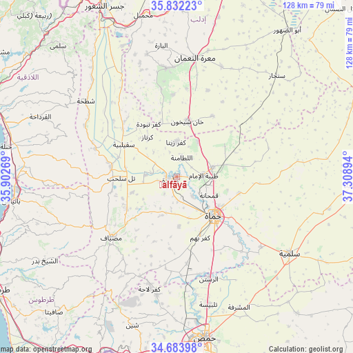
Ḩalfāyā GPS coordinates[2]
35° 15' 36.504" North, 36° 36' 20.916" East
| Map corner | latitude | longitude |
|---|---|---|
| Upper-left | 35.83223°, | 35.90269° |
| Center: | 35.26014°, | 36.60581° |
| Lower-right: | 34.68398°, | 37.30894° |
| Map W x H: | 127.7×127.7 km | = 79.3×79.3mi |
| max Lat: | 37.17701° ⇑46.3% North |
| Ḩalfāyā: | 35.26014° |
| min Lat: | ⇓53.7% South 32.39332° |
| min Long | Ḩalfāyā | max Long |
| 35.75572° | 36.60581° | 42.14006° |
| W 51.6%⇐ | ⇒48.4% E |
Elevation
Elevation of Ḩalfāyā is 301 m = 988 ft, and this is 228.1 m = 748 ft below average elevation for this country.
| Max E: |
1640 m = 5381 ft | 78.8% |
| Avg. | 529.1 m = 1736 ft | |
| Ḩalfāyā | 301 m = 988 ft | |
Min E: |
4 m = 13 ft | 21.2% |
See also: Syria elevation on elevation.city.
Geographical zone
Ḩalfāyā is located in North temperate zone (between Tropic of Cancer and the Arctic Circle). Distance of this Northern Tropic circle is 1314.6 km =816.9 mi to South.| Distance of | km | miles | from Ḩalfāyā |
|---|---|---|---|
| North Pole | 6086.5 | 3782 | to North |
| Arctic Circle | 3480.6 | 2162.7 | to North |
| Tropic Cancer | 1314.6 | 816.9 | to South |
| Equator | 3920.6 | 2436.1 | to South |


Nearby cities:
15 places around Ḩalfāyā: (largest is in red/bold)
• As Suqaylibīyah
22.6 km =14 mi,  301°
301°
• At Tamāni‘ah
25.6 km =15.9 mi,  30°
30°
• Jubb Ramlah
16.9 km =10.5 mi,  250°
250°
• Kafr Zaytā
12.7 km =7.9 mi,  358°
358°
• Khān Shaykhūn
20.6 km =12.8 mi,  11°
11°
• Kurnāz
18 km =11.2 mi,  323°
323°
• Muḩradah
3.3 km =2.1 mi, 245°
• Mūrak
15 km =9.3 mi, 30°
• Qal‘at al Maḑīq
26 km =16.2 mi,  311°
311°
• Souran
13.4 km =8.3 mi,  74°
74°
• Tall Salḩab
20.1 km =12.5 mi,  269°
269°
• Tremseh
9.3 km =5.8 mi,  277°
277°
• Ţayyibat al Imām
9.7 km =6 mi,  86°
86°
• Ḩamāh
19.9 km =12.4 mi,  135°
135°
• Ḩīsh
32.2 km =20 mi, 6°
Sources, notices
• [Note1] Compared only with cities in Syria existing in our database
• [Src1] Map data: © OpenStreetMap contributors (CC-BY-SA)
• [Src2] Other city data from geonames.org with taken over terms of usage.
• [Src3] Geographical zone / Annual Mean Temperature by Robert A. Rohde @ Wikipedia
