Al Qaḩţānīyah geodata
Al Qaḩţānīyah (Al-Hasakah) is a seat of a third-order administrative division; located in Syria in Asia/Damascus (GMT+3) time zone. In our database, there are 87 cities with bigger population. Compared to other cities in Syria, 98.6% of cities are located further ↓South; 98.9% of cities are located further ←West and 61.1% of cities have higher elevation than Al Qaḩţānīyah. Note1


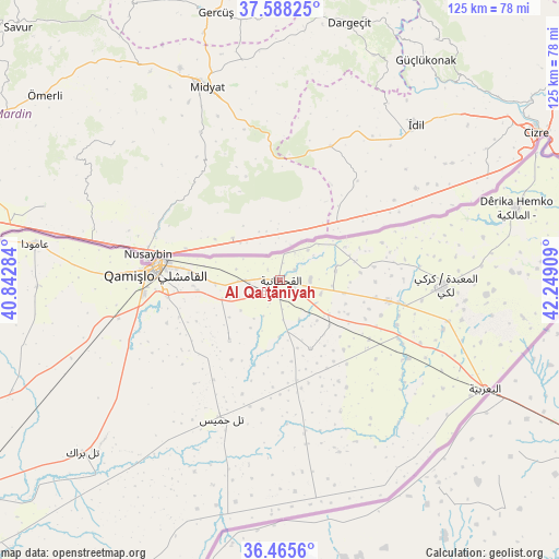
Al Qaḩţānīyah GPS coordinates[2]
37° 1' 44.4" North, 41° 32' 45.456" East
| Map corner | latitude | longitude |
|---|---|---|
| Upper-left | 37.58825°, | 40.84284° |
| Center: | 37.029°, | 41.54596° |
| Lower-right: | 36.4656°, | 42.24909° |
| Map W x H: | 124.8×124.8 km | = 77.5×77.5mi |
| max Lat: | 37.17701° ⇑1.4% North |
| Al Qaḩţānīyah: | 37.029° |
| min Lat: | ⇓98.6% South 32.39332° |
| min Long | Al Qaḩţānī | max Long |
| 35.75572° | 41.54596° | 42.14006° |
| W 98.9%⇐ | ⇒1.1% E |
Elevation
Elevation of Al Qaḩţānīyah is 400 m = 1312 ft, and this is 129.1 m = 424 ft below average elevation for this country.
| Max E: |
1640 m = 5381 ft | 61.1% |
| Avg. | 529.1 m = 1736 ft | |
| Al Qaḩţānīyah | 400 m = 1312 ft | |
Min E: |
4 m = 13 ft | 38.9% |
See also: Syria elevation on elevation.city.
Geographical zone
Al Qaḩţānīyah is located in North temperate zone (between Tropic of Cancer and the Arctic Circle). Distance of this Northern Tropic circle is 1511.3 km =939.1 mi to South.| Distance of | km | miles | from Al Qaḩţānīyah |
|---|---|---|---|
| North Pole | 5889.8 | 3659.8 | to North |
| Arctic Circle | 3283.9 | 2040.5 | to North |
| Tropic Cancer | 1511.3 | 939.1 | to South |
| Equator | 4117.2 | 2558.3 | to South |


Nearby cities:
15 places around Al Qaḩţānīyah: (largest is in red/bold)
• Ad Darbāsīyah
79.5 km =49.4 mi,  273°
273°
• Al Jawādīyah
24.8 km =15.4 mi,  100°
100°
• Al Mālikīyah
55.2 km =34.3 mi,  72°
72°
• Al Qāmishlī
28 km =17.4 mi,  275°
275°
• Al Ya‘rubīyah
51.9 km =32.2 mi,  117°
117°
• Al Ḩasakah
92.1 km =57.2 mi,  230°
230°
• Al Ḩawl
79.3 km =49.3 mi,  206°
206°
• Amude
55.3 km =34.4 mi, 278°
• Ash Shaddādah
130.1 km =80.8 mi, 213°
• Bi’r al Ḩulw al Wardīyah
58.5 km =36.4 mi, 230°
• Markadah
159.3 km =99 mi, 206°
• Ra’s al ‘Ayn
132.6 km =82.4 mi,  261°
261°
• Tall Tamr
112.5 km =69.9 mi,  248°
248°
• Tall Ḩamīs
33 km =20.5 mi,  203°
203°
• ‘Arīshah
112.4 km =69.8 mi,  217°
217°
Sources, notices
• [Note1] Compared only with cities in Syria existing in our database
• [Src1] Map data: © OpenStreetMap contributors (CC-BY-SA)
• [Src2] Other city data from geonames.org with taken over terms of usage.
• [Src3] Geographical zone / Annual Mean Temperature by Robert A. Rohde @ Wikipedia
