Amude geodata
Amude (Al-Hasakah) is a seat of a third-order administrative division; located in Syria in Asia/Damascus (GMT+3) time zone. In our database, there are 87 cities with bigger population. Compared to other cities in Syria, 99.6% of cities are located further ↓South; 96.8% of cities are located further ←West and 50.9% of cities have lower elevation than Amude. Note1


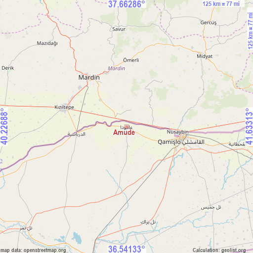
Amude GPS coordinates[2]
37° 6' 15.012" North, 40° 55' 48" East
| Map corner | latitude | longitude |
|---|---|---|
| Upper-left | 37.66286°, | 40.22688° |
| Center: | 37.10417°, | 40.93° |
| Lower-right: | 36.54133°, | 41.63313° |
| Map W x H: | 124.7×124.7 km | = 77.5×77.5mi |
| max Lat: | 37.17701° ⇑0.4% North |
| Amude: | 37.10417° |
| min Lat: | ⇓99.6% South 32.39332° |
| min Long | Amude | max Long |
| 35.75572° | 40.93° | 42.14006° |
| W 96.8%⇐ | ⇒3.2% E |
Elevation
Elevation of Amude is 472 m = 1549 ft, and this is 57.1 m = 187 ft below average elevation for this country.
| Max E: |
1640 m = 5381 ft | 49.1% |
| Avg. | 529.1 m = 1736 ft | |
| Amude | 472 m = 1549 ft | |
Min E: |
4 m = 13 ft | 50.9% |
See also: Syria elevation on elevation.city.
Geographical zone
Amude is located in North temperate zone (between Tropic of Cancer and the Arctic Circle). Distance of this Northern Tropic circle is 1519.7 km =944.3 mi to South.| Distance of | km | miles | from Amude |
|---|---|---|---|
| North Pole | 5881.5 | 3654.6 | to North |
| Arctic Circle | 3275.6 | 2035.4 | to North |
| Tropic Cancer | 1519.7 | 944.3 | to South |
| Equator | 4125.6 | 2563.5 | to South |


Nearby cities:
15 places around Amude: (largest is in red/bold)
• Ad Darbāsīyah
24.9 km =15.5 mi,  261°
261°
• Al Jawādīyah
80.1 km =49.8 mi,  99°
99°
• Al Mālikīyah
107.6 km =66.9 mi,  85°
85°
• Al Qaḩţānīyah
55.3 km =34.4 mi, 98°
• Al Qāmishlī
27.4 km =17 mi, 102°
• Al Ya‘rubīyah
105.7 km =65.7 mi,  107°
107°
• Al Ḩasakah
68.9 km =42.8 mi,  193°
193°
• Al Ḩawl
81.7 km =50.8 mi,  166°
166°
• Ash Shaddādah
117.7 km =73.1 mi, 188°
• Bi’r al Ḩulw al Wardīyah
46.2 km =28.7 mi, 168°
• Markadah
151.8 km =94.3 mi, 185°
• Ra’s al ‘Ayn
81.4 km =50.6 mi,  249°
249°
• Tall Tamr
70.4 km =43.7 mi,  224°
224°
• Tall Ḩamīs
56.9 km =35.4 mi,  132°
132°
• ‘Arīshah
98 km =60.9 mi, 188°
Sources, notices
• [Note1] Compared only with cities in Syria existing in our database
• [Src1] Map data: © OpenStreetMap contributors (CC-BY-SA)
• [Src2] Other city data from geonames.org with taken over terms of usage.
• [Src3] Geographical zone / Annual Mean Temperature by Robert A. Rohde @ Wikipedia
