Tall Tamr geodata
Tall Tamr (Al-Hasakah) is a seat of a third-order administrative division; located in Syria in Asia/Damascus (GMT+3) time zone. In our database, there are 87 cities with bigger population. Compared to other cities in Syria, 94% of cities are located further ↓South; 91.9% of cities are located further ←West and 75.6% of cities have higher elevation than Tall Tamr. Note1


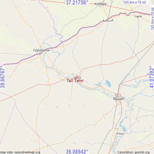
Tall Tamr GPS coordinates[2]
36° 39' 20.016" North, 40° 22' 14.844" East
| Map corner | latitude | longitude |
|---|---|---|
| Upper-left | 37.21756°, | 39.66767° |
| Center: | 36.65556°, | 40.37079° |
| Lower-right: | 36.08942°, | 41.07392° |
| Map W x H: | 125.4×125.4 km | = 77.9×77.9mi |
| max Lat: | 37.17701° ⇑6% North |
| Tall Tamr: | 36.65556° |
| min Lat: | ⇓94% South 32.39332° |
| min Long | Tall Tamr | max Long |
| 35.75572° | 40.37079° | 42.14006° |
| W 91.9%⇐ | ⇒8.1% E |
Elevation
Elevation of Tall Tamr is 331 m = 1086 ft, and this is 198.1 m = 650 ft below average elevation for this country.
| Max E: |
1640 m = 5381 ft | 75.6% |
| Avg. | 529.1 m = 1736 ft | |
| Tall Tamr | 331 m = 1086 ft | |
Min E: |
4 m = 13 ft | 24.4% |
See also: Syria elevation on elevation.city.
Geographical zone
Tall Tamr is located in North temperate zone (between Tropic of Cancer and the Arctic Circle). Distance of this Northern Tropic circle is 1469.8 km =913.3 mi to South.| Distance of | km | miles | from Tall Tamr |
|---|---|---|---|
| North Pole | 5931.3 | 3685.5 | to North |
| Arctic Circle | 3325.5 | 2066.4 | to North |
| Tropic Cancer | 1469.8 | 913.3 | to South |
| Equator | 4075.7 | 2532.5 | to South |


Nearby cities:
15 places around Tall Tamr: (largest is in red/bold)
• Ad Darbāsīyah
52.7 km =32.7 mi,  28°
28°
• Al Qaḩţānīyah
112.5 km =69.9 mi,  68°
68°
• Al Qāmishlī
88.4 km =54.9 mi,  60°
60°
• Al Ḩasakah
37.7 km =23.4 mi,  116°
116°
• Al Ḩawl
75.6 km =47 mi,  112°
112°
• Amude
70.4 km =43.7 mi,  44°
44°
• Ash Shaddādah
74.1 km =46 mi,  153°
153°
• At Tibnī
126.2 km =78.4 mi,  203°
203°
• Bi’r al Ḩulw al Wardīyah
59.4 km =36.9 mi,  85°
85°
• Markadah
106.8 km =66.4 mi,  161°
161°
• Ma‘dān
121.8 km =75.7 mi,  214°
214°
• Ra’s al ‘Ayn
34.4 km =21.4 mi,  308°
308°
• Sulūk
110.9 km =68.9 mi,  266°
266°
• Tall Ḩamīs
92.4 km =57.4 mi,  83°
83°
• ‘Arīshah
59.3 km =36.8 mi,  142°
142°
Sources, notices
• [Note1] Compared only with cities in Syria existing in our database
• [Src1] Map data: © OpenStreetMap contributors (CC-BY-SA)
• [Src2] Other city data from geonames.org with taken over terms of usage.
• [Src3] Geographical zone / Annual Mean Temperature by Robert A. Rohde @ Wikipedia
