‘Arīshah geodata
‘Arīshah (Al-Hasakah) is a seat of a third-order administrative division; located in Syria in Asia/Damascus (GMT+3) time zone. In our database, there are 87 cities with bigger population. Compared to other cities in Syria, 84.1% of cities are located further ↓South; 95.4% of cities are located further ←West and 80.6% of cities have higher elevation than ‘Arīshah. Note1


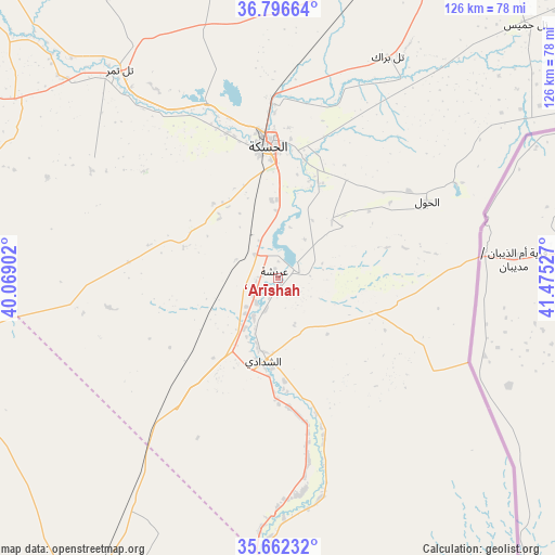
‘Arīshah GPS coordinates[2]
36° 13' 53.544" North, 40° 46' 19.704" East
| Map corner | latitude | longitude |
|---|---|---|
| Upper-left | 36.79664°, | 40.06902° |
| Center: | 36.23154°, | 40.77214° |
| Lower-right: | 35.66232°, | 41.47527° |
| Map W x H: | 126.1×126.1 km | = 78.4×78.4mi |
| max Lat: | 37.17701° ⇑15.9% North |
| ‘Arīshah: | 36.23154° |
| min Lat: | ⇓84.1% South 32.39332° |
| min Long | ‘Arīshah | max Long |
| 35.75572° | 40.77214° | 42.14006° |
| W 95.4%⇐ | ⇒4.6% E |
Elevation
Elevation of ‘Arīshah is 271 m = 889 ft, and this is 258.1 m = 847 ft below average elevation for this country.
| Max E: |
1640 m = 5381 ft | 80.6% |
| Avg. | 529.1 m = 1736 ft | |
| ‘Arīshah | 271 m = 889 ft | |
Min E: |
4 m = 13 ft | 19.4% |
See also: Syria elevation on elevation.city.
Geographical zone
‘Arīshah is located in North temperate zone (between Tropic of Cancer and the Arctic Circle). Distance of this Northern Tropic circle is 1422.7 km =884 mi to South.| Distance of | km | miles | from ‘Arīshah |
|---|---|---|---|
| North Pole | 5978.5 | 3714.9 | to North |
| Arctic Circle | 3372.6 | 2095.6 | to North |
| Tropic Cancer | 1422.7 | 884 | to South |
| Equator | 4028.6 | 2503.3 | to South |


Nearby cities:
15 places around ‘Arīshah: (largest is in red/bold)
• Ad Darbāsīyah
94.2 km =58.5 mi,  353°
353°
• Al Kasrah
106.5 km =66.2 mi,  226°
226°
• Al Qaḩţānīyah
112.4 km =69.8 mi,  37°
37°
• Al Qāmishlī
100 km =62.1 mi,  24°
24°
• Al Ḩasakah
30.2 km =18.8 mi,  355°
355°
• Al Ḩawl
38.2 km =23.7 mi,  62°
62°
• Amude
98 km =60.9 mi,  8°
8°
• Ash Shaddādah
19.6 km =12.2 mi,  189°
189°
• At Tibnī
110.1 km =68.4 mi, 231°
• Bi’r al Ḩulw al Wardīyah
56.8 km =35.3 mi, 24°
• Khushām
112.3 km =69.8 mi,  202°
202°
• Markadah
54 km =33.6 mi,  181°
181°
• Ra’s al ‘Ayn
93.1 km =57.8 mi,  317°
317°
• Tall Tamr
59.3 km =36.8 mi, 322°
• Tall Ḩamīs
81 km =50.3 mi, 43°
Sources, notices
• [Note1] Compared only with cities in Syria existing in our database
• [Src1] Map data: © OpenStreetMap contributors (CC-BY-SA)
• [Src2] Other city data from geonames.org with taken over terms of usage.
• [Src3] Geographical zone / Annual Mean Temperature by Robert A. Rohde @ Wikipedia
