Ra’s al ‘Ayn geodata
Ra’s al ‘Ayn (Al-Hasakah) is a seat of a second-order administrative division; located in Syria in Asia/Damascus (GMT+3) time zone. In our database, there are 87 cities with bigger population. Compared to other cities in Syria, 97.5% of cities are located further ↓South; 90.5% of cities are located further ←West and 68.2% of cities have higher elevation than Ra’s al ‘Ayn. Note1


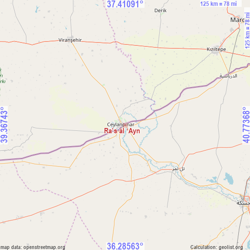
Ra’s al ‘Ayn GPS coordinates[2]
36° 51' 1.224" North, 40° 4' 13.98" East
| Map corner | latitude | longitude |
|---|---|---|
| Upper-left | 37.41091°, | 39.36743° |
| Center: | 36.85034°, | 40.07055° |
| Lower-right: | 36.28563°, | 40.77368° |
| Map W x H: | 125.1×125.1 km | = 77.7×77.7mi |
| max Lat: | 37.17701° ⇑2.5% North |
| Ra’s al ‘Ayn: | 36.85034° |
| min Lat: | ⇓97.5% South 32.39332° |
| min Long | Ra’s al ‘Ay | max Long |
| 35.75572° | 40.07055° | 42.14006° |
| W 90.5%⇐ | ⇒9.5% E |
Elevation
Elevation of Ra’s al ‘Ayn is 359 m = 1178 ft, and this is 170.1 m = 558 ft below average elevation for this country.
| Max E: |
1640 m = 5381 ft | 68.2% |
| Avg. | 529.1 m = 1736 ft | |
| Ra’s al ‘Ayn | 359 m = 1178 ft | |
Min E: |
4 m = 13 ft | 31.8% |
See also: Syria elevation on elevation.city.
Geographical zone
Ra’s al ‘Ayn is located in North temperate zone (between Tropic of Cancer and the Arctic Circle). Distance of this Northern Tropic circle is 1491.5 km =926.8 mi to South.| Distance of | km | miles | from Ra’s al ‘Ayn |
|---|---|---|---|
| North Pole | 5909.7 | 3672.1 | to North |
| Arctic Circle | 3303.8 | 2052.9 | to North |
| Tropic Cancer | 1491.5 | 926.8 | to South |
| Equator | 4097.4 | 2546 | to South |


Nearby cities:
15 places around Ra’s al ‘Ayn: (largest is in red/bold)
• Ad Darbāsīyah
57.3 km =35.6 mi,  64°
64°
• Al Karāmah
130.2 km =80.9 mi,  213°
213°
• Al Qāmishlī
105.6 km =65.6 mi,  77°
77°
• Al Ḩasakah
71.7 km =44.6 mi,  122°
122°
• Al Ḩawl
109 km =67.7 mi, 117°
• Amude
81.4 km =50.6 mi,  69°
69°
• Ash Shaddādah
106.3 km =66.1 mi,  146°
146°
• Bi’r al Ḩulw al Wardīyah
87.6 km =54.4 mi,  101°
101°
• Ma‘dān
128.9 km =80.1 mi,  199°
199°
• Sulūk
88.5 km =55 mi,  251°
251°
• Tall Abyaḑ
100.9 km =62.7 mi,  260°
260°
• Tall Tamr
34.4 km =21.4 mi,  128°
128°
• Tall Ḩamīs
118.8 km =73.8 mi, 95°
• ‘Arīshah
93.1 km =57.8 mi,  137°
137°
• ‘Ayn ‘Īsá
119.6 km =74.3 mi,  244°
244°
Sources, notices
• [Note1] Compared only with cities in Syria existing in our database
• [Src1] Map data: © OpenStreetMap contributors (CC-BY-SA)
• [Src2] Other city data from geonames.org with taken over terms of usage.
• [Src3] Geographical zone / Annual Mean Temperature by Robert A. Rohde @ Wikipedia
