Hajīn geodata
Hajīn (Deir ez-Zor) is a seat of a third-order administrative division; located in Syria in Asia/Damascus (GMT+3) time zone. With population of 29,237 people, there are 53 cities with bigger population in this country. Compared to other cities in Syria, 68.6% of cities are located further ↑North; 95.8% of cities are located further ←West and 92.9% of cities have higher elevation than Hajīn. Note1


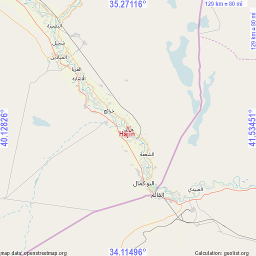
Hajīn GPS coordinates[2]
34° 41' 42.288" North, 40° 49' 52.968" East
| Map corner | latitude | longitude |
|---|---|---|
| Upper-left | 35.27116°, | 40.12826° |
| Center: | 34.69508°, | 40.83138° |
| Lower-right: | 34.11496°, | 41.53451° |
| Map W x H: | 128.6×128.6 km | = 79.9×79.9mi |
| max Lat: | 37.17701° ⇑68.6% North |
| Hajīn: | 34.69508° |
| min Lat: | ⇓31.4% South 32.39332° |
| min Long | Hajīn | max Long |
| 35.75572° | 40.83138° | 42.14006° |
| W 95.8%⇐ | ⇒4.2% E |
Elevation
Elevation of Hajīn is 182 m = 597 ft, and this is 347.1 m = 1139 ft below average elevation for this country.
| Max E: |
1640 m = 5381 ft | 92.9% |
| Avg. | 529.1 m = 1736 ft | |
| Hajīn | 182 m = 597 ft | |
Min E: |
4 m = 13 ft | 7.1% |
See also: Syria elevation on elevation.city.
Geographical zone
Hajīn is located in North temperate zone (between Tropic of Cancer and the Arctic Circle). Distance of this Northern Tropic circle is 1251.8 km =777.8 mi to South.| Distance of | km | miles | from Hajīn |
|---|---|---|---|
| North Pole | 6149.3 | 3821 | to North |
| Arctic Circle | 3543.4 | 2201.8 | to North |
| Tropic Cancer | 1251.8 | 777.8 | to South |
| Equator | 3857.7 | 2397.1 | to South |


Nearby cities:
15 places around Hajīn: (largest is in red/bold)
• Al Buşayrah
63.1 km =39.2 mi,  324°
324°
• Al Jalā’
6.9 km =4.3 mi,  173°
173°
• Al Kasrah
127.6 km =79.3 mi, 319°
• Al Mayādīn
50 km =31.1 mi, 316°
• Al ‘Ashārah
35.3 km =21.9 mi, 315°
• As Sūsah
21.4 km =13.3 mi,  147°
147°
• Ash Shaddādah
151.7 km =94.3 mi,  356°
356°
• At Tibnī
137.4 km =85.4 mi, 317°
• Deir ez-Zor
95 km =59 mi, 318°
• Dhībān
46.1 km =28.6 mi, 320°
• Khushām
83.5 km =51.9 mi, 323°
• Markadah
117.1 km =72.8 mi, 356°
• Mūḩ Ḩasan
76.1 km =47.3 mi, 321°
• Subaykhān
27.5 km =17.1 mi,  309°
309°
• Ālbū Kamāl
28.2 km =17.5 mi,  163°
163°
Sources, notices
• [Note1] Compared only with cities in Syria existing in our database
• [Src1] Map data: © OpenStreetMap contributors (CC-BY-SA)
• [Src2] Other city data from geonames.org with taken over terms of usage.
• [Src3] Geographical zone / Annual Mean Temperature by Robert A. Rohde @ Wikipedia
