Lat Phrao geodata
Lat Phrao (Bangkok) is a seat of a second-order administrative division; located in Thailand in Asia/Bangkok (GMT+7) time zone. In our database, there are 331 cities with bigger population. Compared to other cities in Thailand, 68% of cities are located further ↑North; 53.6% of cities are located further →East and 96.7% of cities have higher elevation than Lat Phrao. Note1


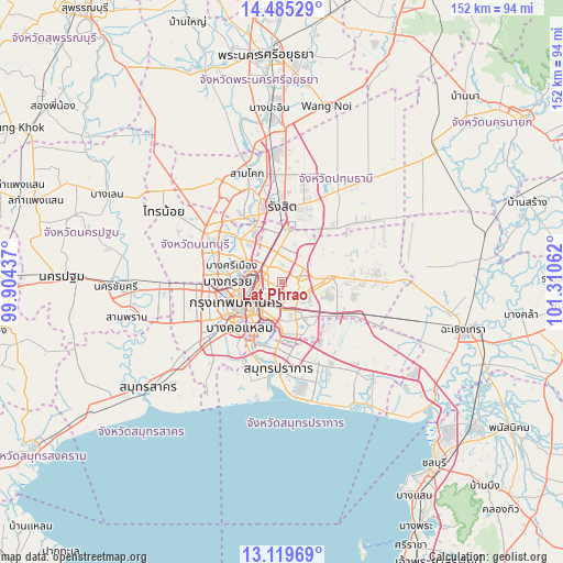
Lat Phrao GPS coordinates[2]
13° 48' 12.564" North, 100° 36' 26.964" East
| Map corner | latitude | longitude |
|---|---|---|
| Upper-left | 14.48529°, | 99.90437° |
| Center: | 13.80349°, | 100.60749° |
| Lower-right: | 13.11969°, | 101.31062° |
| Map W x H: | 151.8×151.8 km | = 94.3×94.3mi |
| max Lat: | 20.43353° ⇑68% North |
| Lat Phrao: | 13.80349° |
| min Lat: | ⇓32% South 5.77434° |
| min Long | Lat Phrao | max Long |
| 97.93288° | 100.60749° | 105.49506° |
| W 46.4%⇐ | ⇒53.6% E |
Elevation
Elevation of Lat Phrao is 6 m = 20 ft, and this is 119.5 m = 392 ft below average elevation for this country.
| Max E: |
1011 m = 3317 ft | 96.7% |
| Avg. | 125.5 m = 412 ft | |
| Lat Phrao | 6 m = 20 ft | |
Min E: |
1 m = 3 ft | 3.3% |
See also: Thailand elevation on elevation.city.
Geographical zone
Lat Phrao is located in North Torrid zone (between Equator and Tropic of Cancer). Distance of this Northern Tropic circle is 1071.1 km =665.6 mi to North.| Distance of | km | miles | from Lat Phrao |
|---|---|---|---|
| North Pole | 8472.3 | 5264.4 | to North |
| Arctic Circle | 5866.4 | 3645.2 | to North |
| Tropic Cancer | 1071.1 | 665.6 | to North |
| Equator | 1534.8 | 953.7 | to South |


Nearby cities:
15 places around Lat Phrao: (largest is in red/bold)
• Bang Kapi
6 km =3.7 mi,  134°
134°
• Bang Sue
7.6 km =4.7 mi,  275°
275°
• Bueng Kum
7 km =4.3 mi,  106°
106°
• Chatuchak
5.9 km =3.7 mi,  298°
298°
• Din Daeng
7 km =4.3 mi,  237°
237°
• Dusit
9.9 km =6.2 mi,  253°
253°
• Huai Khwang
4.3 km =2.7 mi,  226°
226°
• Khan Na Yao
8.2 km =5.1 mi,  72°
72°
• Khlong Toei
10.4 km =6.5 mi,  201°
201°
• Phaya Thai
7.5 km =4.7 mi, 249°
• Ratchathewi
9.4 km =5.8 mi, 238°
• Saphan Sung
9.2 km =5.7 mi, 113°
• Suan Luang
9.4 km =5.8 mi,  149°
149°
• Wang Thonglang
2.1 km =1.3 mi,  167°
167°
• Watthana
8.5 km =5.3 mi, 196°
Sources, notices
• [Note1] Compared only with cities in Thailand existing in our database
• [Src1] Map data: © OpenStreetMap contributors (CC-BY-SA)
• [Src2] Other city data from geonames.org with taken over terms of usage.
• [Src3] Geographical zone / Annual Mean Temperature by Robert A. Rohde @ Wikipedia
