Suan Luang geodata
Suan Luang (Bangkok) is a seat of a second-order administrative division; located in Thailand in Asia/Bangkok (GMT+7) time zone. In our database, there are 331 cities with bigger population. Compared to other cities in Thailand, 70.6% of cities are located further ↑North; 52.6% of cities are located further →East and 85.9% of cities have higher elevation than Suan Luang. Note1


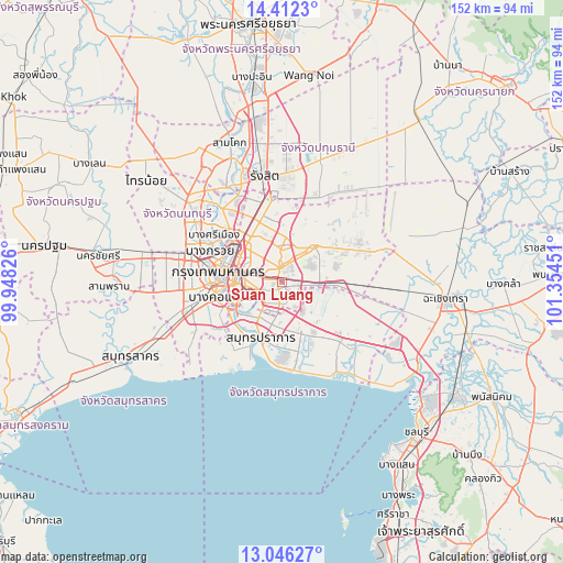
Suan Luang GPS coordinates[2]
13° 43' 49.008" North, 100° 39' 4.968" East
| Map corner | latitude | longitude |
|---|---|---|
| Upper-left | 14.4123°, | 99.94826° |
| Center: | 13.73028°, | 100.65138° |
| Lower-right: | 13.04627°, | 101.35451° |
| Map W x H: | 151.9×151.9 km | = 94.4×94.4mi |
| max Lat: | 20.43353° ⇑70.6% North |
| Suan Luang: | 13.73028° |
| min Lat: | ⇓29.4% South 5.77434° |
| min Long | Suan Luang | max Long |
| 97.93288° | 100.65138° | 105.49506° |
| W 47.4%⇐ | ⇒52.6% E |
Elevation
Elevation of Suan Luang is 10 m = 33 ft, and this is 115.5 m = 379 ft below average elevation for this country.
| Max E: |
1011 m = 3317 ft | 85.9% |
| Avg. | 125.5 m = 412 ft | |
| Suan Luang | 10 m = 33 ft | |
Min E: |
1 m = 3 ft | 14.1% |
See also: Thailand elevation on elevation.city.
Geographical zone
Suan Luang is located in North Torrid zone (between Equator and Tropic of Cancer). Distance of this Northern Tropic circle is 1079.3 km =670.6 mi to North.| Distance of | km | miles | from Suan Luang |
|---|---|---|---|
| North Pole | 8480.4 | 5269.5 | to North |
| Arctic Circle | 5874.5 | 3650.2 | to North |
| Tropic Cancer | 1079.3 | 670.6 | to North |
| Equator | 1526.7 | 948.6 | to South |


Nearby cities:
15 places around Suan Luang: (largest is in red/bold)
• Bang Kapi
3.9 km =2.4 mi,  353°
353°
• Bang Na
7.1 km =4.4 mi,  188°
188°
• Bueng Kum
6.4 km =4 mi,  17°
17°
• Din Daeng
11.5 km =7.1 mi,  292°
292°
• Huai Khwang
9.4 km =5.8 mi,  303°
303°
• Khan Na Yao
11.1 km =6.9 mi, 15°
• Khlong Toei
8.8 km =5.5 mi,  260°
260°
• Lat Phrao
9.4 km =5.8 mi,  329°
329°
• Min Buri
12.7 km =7.9 mi,  42°
42°
• Phaya Thai
13 km =8.1 mi, 295°
• Phra Khanong
6.2 km =3.9 mi,  239°
239°
• Saphan Sung
5.8 km =3.6 mi, 39°
• Wang Thonglang
7.5 km =4.7 mi, 325°
• Watthana
7.1 km =4.4 mi,  269°
269°
• Yan Nawa
12.4 km =7.7 mi,  252°
252°
Sources, notices
• [Note1] Compared only with cities in Thailand existing in our database
• [Src1] Map data: © OpenStreetMap contributors (CC-BY-SA)
• [Src2] Other city data from geonames.org with taken over terms of usage.
• [Src3] Geographical zone / Annual Mean Temperature by Robert A. Rohde @ Wikipedia
