Khan Na Yao geodata
Khan Na Yao (Bangkok) is a seat of a second-order administrative division; located in Thailand in Asia/Bangkok (GMT+7) time zone. In our database, there are 331 cities with bigger population. Compared to other cities in Thailand, 67.2% of cities are located further ↑North; 51.9% of cities are located further →East and 70.3% of cities have higher elevation than Khan Na Yao. Note1


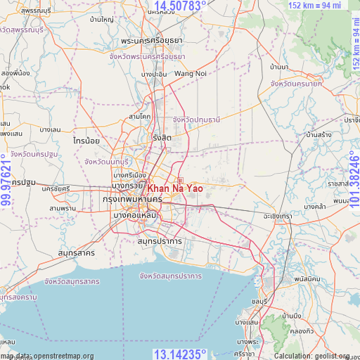
Khan Na Yao GPS coordinates[2]
13° 49' 33.924" North, 100° 40' 45.588" East
| Map corner | latitude | longitude |
|---|---|---|
| Upper-left | 14.50783°, | 99.97621° |
| Center: | 13.82609°, | 100.67933° |
| Lower-right: | 13.14235°, | 101.38246° |
| Map W x H: | 151.8×151.8 km | = 94.3×94.3mi |
| max Lat: | 20.43353° ⇑67.2% North |
| Khan Na Yao: | 13.82609° |
| min Lat: | ⇓32.8% South 5.77434° |
| min Long | Khan Na Yao | max Long |
| 97.93288° | 100.67933° | 105.49506° |
| W 48.1%⇐ | ⇒51.9% E |
Elevation
Elevation of Khan Na Yao is 22 m = 72 ft, and this is 103.5 m = 340 ft below average elevation for this country.
| Max E: |
1011 m = 3317 ft | 70.3% |
| Avg. | 125.5 m = 412 ft | |
| Khan Na Yao | 22 m = 72 ft | |
Min E: |
1 m = 3 ft | 29.7% |
See also: Thailand elevation on elevation.city.
Geographical zone
Khan Na Yao is located in North Torrid zone (between Equator and Tropic of Cancer). Distance of this Northern Tropic circle is 1068.6 km =664 mi to North.| Distance of | km | miles | from Khan Na Yao |
|---|---|---|---|
| North Pole | 8469.7 | 5262.8 | to North |
| Arctic Circle | 5863.9 | 3643.7 | to North |
| Tropic Cancer | 1068.6 | 664 | to North |
| Equator | 1537.3 | 955.2 | to South |


Nearby cities:
15 places around Khan Na Yao: (largest is in red/bold)
• Bang Kapi
7.6 km =4.7 mi,  207°
207°
• Bueng Kum
4.7 km =2.9 mi,  193°
193°
• Chatuchak
12.9 km =8 mi,  271°
271°
• Din Daeng
15 km =9.3 mi,  245°
245°
• Don Mueang
13.7 km =8.5 mi,  315°
315°
• Huai Khwang
12.1 km =7.5 mi,  243°
243°
• Khlong Sam Wa
6.1 km =3.8 mi,  79°
79°
• Lam Luk Ka
14 km =8.7 mi,  32°
32°
• Lat Phrao
8.2 km =5.1 mi, 252°
• Min Buri
5.8 km =3.6 mi,  103°
103°
• Sai Mai
11.1 km =6.9 mi,  340°
340°
• Saphan Sung
6.2 km =3.9 mi,  174°
174°
• Suan Luang
11.1 km =6.9 mi,  195°
195°
• Wang Thonglang
8.6 km =5.3 mi, 238°
• Watthana
14.8 km =9.2 mi,  223°
223°
Sources, notices
• [Note1] Compared only with cities in Thailand existing in our database
• [Src1] Map data: © OpenStreetMap contributors (CC-BY-SA)
• [Src2] Other city data from geonames.org with taken over terms of usage.
• [Src3] Geographical zone / Annual Mean Temperature by Robert A. Rohde @ Wikipedia
