Phra Khanong geodata
Phra Khanong (Bangkok) is a seat of a second-order administrative division; located in Thailand in Asia/Bangkok (GMT+7) time zone. In our database, there are 331 cities with bigger population. Compared to other cities in Thailand, 71.8% of cities are located further ↑North; 53.7% of cities are located further →East and 85.9% of cities have higher elevation than Phra Khanong. Note1


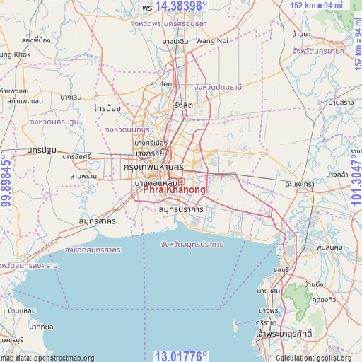
Phra Khanong GPS coordinates[2]
13° 42' 6.66" North, 100° 36' 5.652" East
| Map corner | latitude | longitude |
|---|---|---|
| Upper-left | 14.38396°, | 99.89845° |
| Center: | 13.70185°, | 100.60157° |
| Lower-right: | 13.01776°, | 101.3047° |
| Map W x H: | 151.9×151.9 km | = 94.4×94.4mi |
| max Lat: | 20.43353° ⇑71.8% North |
| Phra Khanong: | 13.70185° |
| min Lat: | ⇓28.2% South 5.77434° |
| min Long | Phra Khanong | max Long |
| 97.93288° | 100.60157° | 105.49506° |
| W 46.3%⇐ | ⇒53.7% E |
Elevation
Elevation of Phra Khanong is 10 m = 33 ft, and this is 115.5 m = 379 ft below average elevation for this country.
| Max E: |
1011 m = 3317 ft | 85.9% |
| Avg. | 125.5 m = 412 ft | |
| Phra Khanong | 10 m = 33 ft | |
Min E: |
1 m = 3 ft | 14.1% |
See also: Thailand elevation on elevation.city.
Geographical zone
Phra Khanong is located in North Torrid zone (between Equator and Tropic of Cancer). Distance of this Northern Tropic circle is 1082.4 km =672.6 mi to North.| Distance of | km | miles | from Phra Khanong |
|---|---|---|---|
| North Pole | 8483.6 | 5271.5 | to North |
| Arctic Circle | 5877.7 | 3652.2 | to North |
| Tropic Cancer | 1082.4 | 672.6 | to North |
| Equator | 1523.5 | 946.7 | to South |


Nearby cities:
15 places around Phra Khanong: (largest is in red/bold)
• Bang Kapi
8.6 km =5.3 mi,  34°
34°
• Bang Na
5.8 km =3.6 mi,  131°
131°
• Bang Rak
9 km =5.6 mi,  290°
290°
• Din Daeng
9.2 km =5.7 mi,  325°
325°
• Huai Khwang
8.7 km =5.4 mi,  343°
343°
• Khlong Toei
3.6 km =2.2 mi,  296°
296°
• Pathum Wan
9.2 km =5.7 mi, 294°
• Phra Pradaeng
8.8 km =5.5 mi,  236°
236°
• Ratchathewi
9.7 km =6 mi,  310°
310°
• Samphanthawong
10 km =6.2 mi, 289°
• Sathon
8.2 km =5.1 mi,  275°
275°
• Suan Luang
6.2 km =3.9 mi,  59°
59°
• Wang Thonglang
9.4 km =5.8 mi,  6°
6°
• Watthana
3.6 km =2.2 mi, 330°
• Yan Nawa
6.5 km =4 mi,  264°
264°
Sources, notices
• [Note1] Compared only with cities in Thailand existing in our database
• [Src1] Map data: © OpenStreetMap contributors (CC-BY-SA)
• [Src2] Other city data from geonames.org with taken over terms of usage.
• [Src3] Geographical zone / Annual Mean Temperature by Robert A. Rohde @ Wikipedia
