Sirindhorn geodata
Sirindhorn (Changwat Ubon Ratchathani) is a seat of a second-order administrative division; located in Thailand in Asia/Bangkok (GMT+7) time zone. In our database, there are 331 cities with bigger population. Compared to other cities in Thailand, 52.8% of cities are located further ↓South; 99.8% of cities are located further ←West and 63.6% of cities have lower elevation than Sirindhorn. Note1


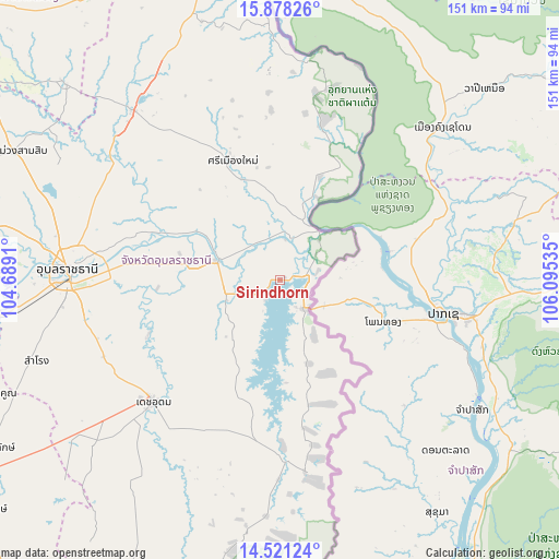
Sirindhorn GPS coordinates[2]
15° 12' 3.024" North, 105° 23' 31.992" East
| Map corner | latitude | longitude |
|---|---|---|
| Upper-left | 15.87826°, | 104.6891° |
| Center: | 15.20084°, | 105.39222° |
| Lower-right: | 14.52124°, | 106.09535° |
| Map W x H: | 150.9×150.9 km | = 93.8×93.8mi |
| max Lat: | 20.43353° ⇑47.2% North |
| Sirindhorn: | 15.20084° |
| min Lat: | ⇓52.8% South 5.77434° |
| min Long | Sirindhorn | max Long |
| 97.93288° | 105.39222° | 105.49506° |
| W 99.8%⇐ | ⇒0.2% E |
Elevation
Elevation of Sirindhorn is 157 m = 515 ft, and this is 31.5 m = 103 ft above average elevation for this country.
| Max E: |
1011 m = 3317 ft | 36.4% |
| Sirindhorn | 157 m 515 ft | |
| Avg. | 125.5 m = 412 ft | |
Min E: |
1 m = 3 ft | 63.6% |
See also: Thailand elevation on elevation.city.
Geographical zone
Sirindhorn is located in North Torrid zone (between Equator and Tropic of Cancer). Distance of this Northern Tropic circle is 915.7 km =569 mi to North.| Distance of | km | miles | from Sirindhorn |
|---|---|---|---|
| North Pole | 8316.9 | 5167.9 | to North |
| Arctic Circle | 5711 | 3548.6 | to North |
| Tropic Cancer | 915.7 | 569 | to North |
| Equator | 1690.2 | 1050.2 | to South |


Nearby cities:
15 places around Sirindhorn: (largest is in red/bold)
• Buntharik
49.5 km =30.8 mi,  177°
177°
• Det Udom
47 km =29.2 mi,  225°
225°
• Don Mot Daeng
43.8 km =27.2 mi,  296°
296°
• Khong Chiam
17.1 km =10.6 mi,  40°
40°
• Lao Suea Kok
55.8 km =34.7 mi, 295°
• Na Yia
38.8 km =24.1 mi,  246°
246°
• Phibun Mangsahan
18.2 km =11.3 mi,  285°
285°
• Pho Sai
70.9 km =44.1 mi,  348°
348°
• Samrong
68.7 km =42.7 mi, 251°
• Sawang Wirawong
32.5 km =20.2 mi,  278°
278°
• Si Mueang Mai
34.8 km =21.6 mi,  339°
339°
• Tan Sum
28.5 km =17.7 mi, 296°
• Trakan Phut Phon
60.6 km =37.7 mi,  318°
318°
• Ubon Ratchathani
58.5 km =36.4 mi,  274°
274°
• Warin Chamrap
56.8 km =35.3 mi, 269°
Sources, notices
• [Note1] Compared only with cities in Thailand existing in our database
• [Src1] Map data: © OpenStreetMap contributors (CC-BY-SA)
• [Src2] Other city data from geonames.org with taken over terms of usage.
• [Src3] Geographical zone / Annual Mean Temperature by Robert A. Rohde @ Wikipedia
