Phibun Mangsahan geodata
Phibun Mangsahan (Changwat Ubon Ratchathani) is a seat of a second-order administrative division; located in Thailand in Asia/Bangkok (GMT+7) time zone. With population of 19,883 people, there are 157 cities with bigger population in this country. Compared to other cities in Thailand, 53.7% of cities are located further ↓South; 99.3% of cities are located further ←West and 52.5% of cities have lower elevation than Phibun Mangsahan. Note1


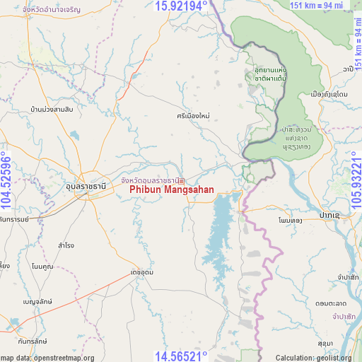
Phibun Mangsahan GPS coordinates[2]
15° 14' 40.812" North, 105° 13' 44.688" East
| Map corner | latitude | longitude |
|---|---|---|
| Upper-left | 15.92194°, | 104.52596° |
| Center: | 15.24467°, | 105.22908° |
| Lower-right: | 14.56521°, | 105.93221° |
| Map W x H: | 150.9×150.9 km | = 93.8×93.8mi |
| max Lat: | 20.43353° ⇑46.3% North |
| Phibun Mangsahan: | 15.24467° |
| min Lat: | ⇓53.7% South 5.77434° |
| min Long | Phibun Mangsaha | max Long |
| 97.93288° | 105.22908° | 105.49506° |
| W 99.3%⇐ | ⇒0.7% E |
Elevation
Elevation of Phibun Mangsahan is 127 m = 417 ft, and this is 1.5 m = 5 ft above average elevation for this country.
| Max E: |
1011 m = 3317 ft | 47.5% |
| Phibun Mangsahan | 127 m 417 ft | |
| Avg. | 125.5 m = 412 ft | |
Min E: |
1 m = 3 ft | 52.5% |
See also: Thailand elevation on elevation.city.
Geographical zone
Phibun Mangsahan is located in North Torrid zone (between Equator and Tropic of Cancer). Distance of this Northern Tropic circle is 910.9 km =566 mi to North.| Distance of | km | miles | from Phibun Mangsahan |
|---|---|---|---|
| North Pole | 8312 | 5164.8 | to North |
| Arctic Circle | 5706.1 | 3545.6 | to North |
| Tropic Cancer | 910.9 | 566 | to North |
| Equator | 1695 | 1053.2 | to South |


Nearby cities:
15 places around Phibun Mangsahan: (largest is in red/bold)
• Buntharik
57.7 km =35.9 mi,  160°
160°
• Det Udom
41 km =25.5 mi,  203°
203°
• Don Mot Daeng
26.2 km =16.3 mi,  304°
304°
• Khong Chiam
29.7 km =18.5 mi,  73°
73°
• Lao Suea Kok
38 km =23.6 mi, 300°
• Muang Sam Sip
61.7 km =38.3 mi, 298°
• Na Yia
27.1 km =16.8 mi,  222°
222°
• Samrong
54.5 km =33.9 mi,  241°
241°
• Sawang Wirawong
14.7 km =9.1 mi,  268°
268°
• Si Mueang Mai
28.1 km =17.5 mi,  10°
10°
• Sirindhorn
18.2 km =11.3 mi,  105°
105°
• Tan Sum
11.2 km =7 mi,  314°
314°
• Trakan Phut Phon
46.5 km =28.9 mi,  331°
331°
• Ubon Ratchathani
40.8 km =25.4 mi, 269°
• Warin Chamrap
39.7 km =24.7 mi,  261°
261°
Sources, notices
• [Note1] Compared only with cities in Thailand existing in our database
• [Src1] Map data: © OpenStreetMap contributors (CC-BY-SA)
• [Src2] Other city data from geonames.org with taken over terms of usage.
• [Src3] Geographical zone / Annual Mean Temperature by Robert A. Rohde @ Wikipedia
