Sai Ngam geodata
Sai Ngam (Kamphaeng Phet) is a seat of a second-order administrative division; located in Thailand in Asia/Bangkok (GMT+7) time zone. In our database, there are 331 cities with bigger population. Compared to other cities in Thailand, 71.8% of cities are located further ↓South; 76.2% of cities are located further →East and 55% of cities have higher elevation than Sai Ngam. Note1


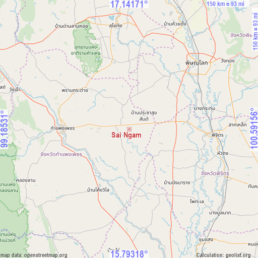
Sai Ngam GPS coordinates[2]
16° 28' 7.032" North, 99° 53' 18.348" East
| Map corner | latitude | longitude |
|---|---|---|
| Upper-left | 17.14171°, | 99.18531° |
| Center: | 16.46862°, | 99.88843° |
| Lower-right: | 15.79318°, | 100.59156° |
| Map W x H: | 149.9×149.9 km | = 93.1×93.1mi |
| max Lat: | 20.43353° ⇑28.2% North |
| Sai Ngam: | 16.46862° |
| min Lat: | ⇓71.8% South 5.77434° |
| min Long | Sai Ngam | max Long |
| 97.93288° | 99.88843° | 105.49506° |
| W 23.8%⇐ | ⇒76.2% E |
Elevation
Elevation of Sai Ngam is 59 m = 194 ft, and this is 66.5 m = 218 ft below average elevation for this country.
| Max E: |
1011 m = 3317 ft | 55% |
| Avg. | 125.5 m = 412 ft | |
| Sai Ngam | 59 m = 194 ft | |
Min E: |
1 m = 3 ft | 45% |
See also: Thailand elevation on elevation.city.
Geographical zone
Sai Ngam is located in North Torrid zone (between Equator and Tropic of Cancer). Distance of this Northern Tropic circle is 774.8 km =481.4 mi to North.| Distance of | km | miles | from Sai Ngam |
|---|---|---|---|
| North Pole | 8175.9 | 5080.3 | to North |
| Arctic Circle | 5570 | 3461 | to North |
| Tropic Cancer | 774.8 | 481.4 | to North |
| Equator | 1831.1 | 1137.8 | to South |


Nearby cities:
15 places around Sai Ngam: (largest is in red/bold)
• Bang Krathum
45.6 km =28.3 mi,  74°
74°
• Bang Rakam
40.4 km =25.1 mi,  37°
37°
• Bueng Na Rang
41.6 km =25.8 mi,  142°
142°
• Bueng Samakkhi
32.6 km =20.3 mi,  163°
163°
• Kamphaeng Phet
39.2 km =24.4 mi,  272°
272°
• Khanu Woralaksaburi
45.3 km =28.1 mi,  183°
183°
• Khiri Mat
41.6 km =25.8 mi,  346°
346°
• Khlong Khlung
33.4 km =20.8 mi,  212°
212°
• Kong Krailat
54.6 km =33.9 mi,  10°
10°
• Lan Krabue
15.2 km =9.4 mi,  343°
343°
• Phichit
49.2 km =30.6 mi,  93°
93°
• Phran Kratai
38.7 km =24 mi,  304°
304°
• Sam Ngam
34 km =21.1 mi,  82°
82°
• Thung Sai
18.1 km =11.2 mi,  199°
199°
• Wachira Barami
28 km =17.4 mi, 77°
Sources, notices
• [Note1] Compared only with cities in Thailand existing in our database
• [Src1] Map data: © OpenStreetMap contributors (CC-BY-SA)
• [Src2] Other city data from geonames.org with taken over terms of usage.
• [Src3] Geographical zone / Annual Mean Temperature by Robert A. Rohde @ Wikipedia
