Kamphaeng Phet geodata
Kamphaeng Phet is a seat of a first-order administrative division; located in Thailand in Asia/Bangkok (GMT+7) time zone. With population of 58,787 people, there are 40 cities with bigger population in this country. Compared to other cities in Thailand, 72% of cities are located further ↓South; 84.5% of cities are located further →East and 51.1% of cities have higher elevation than Kamphaeng Phet. Note1


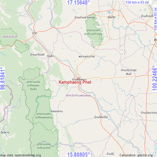
Kamphaeng Phet GPS coordinates[2]
16° 29' 0.384" North, 99° 31' 17.508" East
| Map corner | latitude | longitude |
|---|---|---|
| Upper-left | 17.15648°, | 98.81841° |
| Center: | 16.48344°, | 99.52153° |
| Lower-right: | 15.80805°, | 100.22466° |
| Map W x H: | 149.9×149.9 km | = 93.1×93.1mi |
| max Lat: | 20.43353° ⇑28% North |
| Kamphaeng Phet: | 16.48344° |
| min Lat: | ⇓72% South 5.77434° |
| min Long | Kamphaeng Phet | max Long |
| 97.93288° | 99.52153° | 105.49506° |
| W 15.5%⇐ | ⇒84.5% E |
Elevation
Elevation of Kamphaeng Phet is 83 m = 272 ft, and this is 42.5 m = 139 ft below average elevation for this country.
| Max E: |
1011 m = 3317 ft | 51.1% |
| Avg. | 125.5 m = 412 ft | |
| Kamphaeng Phet | 83 m = 272 ft | |
Min E: |
1 m = 3 ft | 48.9% |
See also: Kamphaeng Phet elevation on elevation.city.
Geographical zone
Kamphaeng Phet is located in North Torrid zone (between Equator and Tropic of Cancer). Distance of this Northern Tropic circle is 773.1 km =480.4 mi to North.| Distance of | km | miles | from Kamphaeng Phet |
|---|---|---|---|
| North Pole | 8174.3 | 5079.3 | to North |
| Arctic Circle | 5568.4 | 3460 | to North |
| Tropic Cancer | 773.1 | 480.4 | to North |
| Equator | 1832.8 | 1138.8 | to South |


Nearby cities:
15 places around Kamphaeng Phet: (largest is in red/bold)
• Ban Dan Lan Hoi
58.5 km =36.4 mi,  5°
5°
• Ban Na
63.5 km =39.5 mi,  20°
20°
• Bueng Samakkhi
58.6 km =36.4 mi,  124°
124°
• Khanu Woralaksaburi
59.2 km =36.8 mi,  142°
142°
• Khiri Mat
48.9 km =30.4 mi,  37°
37°
• Khlong Khlung
36.4 km =22.6 mi, 144°
• Khlong Lan
37.9 km =23.5 mi,  214°
214°
• Kosamphi Nakhon
24.6 km =15.3 mi,  311°
311°
• Lan Krabue
37.2 km =23.1 mi,  69°
69°
• Pang Sila Thong
43.2 km =26.8 mi,  184°
184°
• Phran Kratai
21.4 km =13.3 mi, 19°
• Sai Ngam
39.2 km =24.4 mi,  92°
92°
• Tak
59.9 km =37.2 mi,  315°
315°
• Thung Sai
38.1 km =23.7 mi, 119°
• Wang Chao
34.3 km =21.3 mi, 308°
Sources, notices
• [Note1] Compared only with cities in Thailand existing in our database
• [Src1] Map data: © OpenStreetMap contributors (CC-BY-SA)
• [Src2] Other city data from geonames.org with taken over terms of usage.
• [Src3] Geographical zone / Annual Mean Temperature by Robert A. Rohde @ Wikipedia
