Bang Rakam geodata
Bang Rakam (Phitsanulok) is a seat of a second-order administrative division; located in Thailand in Asia/Bangkok (GMT+7) time zone. With population of 16,841 people, there are 191 cities with bigger population in this country. Compared to other cities in Thailand, 75.5% of cities are located further ↓South; 68.8% of cities are located further →East and 59.1% of cities have higher elevation than Bang Rakam. Note1


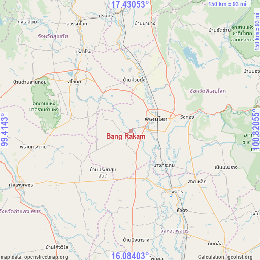
Bang Rakam GPS coordinates[2]
16° 45' 30.492" North, 100° 7' 2.712" East
| Map corner | latitude | longitude |
|---|---|---|
| Upper-left | 17.43053°, | 99.4143° |
| Center: | 16.75847°, | 100.11742° |
| Lower-right: | 16.08403°, | 100.82055° |
| Map W x H: | 149.7×149.7 km | = 93×93mi |
| max Lat: | 20.43353° ⇑24.5% North |
| Bang Rakam: | 16.75847° |
| min Lat: | ⇓75.5% South 5.77434° |
| min Long | Bang Rakam | max Long |
| 97.93288° | 100.11742° | 105.49506° |
| W 31.2%⇐ | ⇒68.8% E |
Elevation
Elevation of Bang Rakam is 47 m = 154 ft, and this is 78.5 m = 258 ft below average elevation for this country.
| Max E: |
1011 m = 3317 ft | 59.1% |
| Avg. | 125.5 m = 412 ft | |
| Bang Rakam | 47 m = 154 ft | |
Min E: |
1 m = 3 ft | 40.9% |
See also: Thailand elevation on elevation.city.
Geographical zone
Bang Rakam is located in North Torrid zone (between Equator and Tropic of Cancer). Distance of this Northern Tropic circle is 742.6 km =461.4 mi to North.| Distance of | km | miles | from Bang Rakam |
|---|---|---|---|
| North Pole | 8143.7 | 5060.3 | to North |
| Arctic Circle | 5537.8 | 3441 | to North |
| Tropic Cancer | 742.6 | 461.4 | to North |
| Equator | 1863.4 | 1157.9 | to South |


Nearby cities:
15 places around Bang Rakam: (largest is in red/bold)
• Ban Na
50 km =31.1 mi,  305°
305°
• Bang Krathum
27.9 km =17.3 mi,  135°
135°
• Khiri Mat
34.8 km =21.6 mi,  283°
283°
• Kong Krailat
26.2 km =16.3 mi,  325°
325°
• Lan Krabue
33.6 km =20.9 mi,  238°
238°
• Phichit
43 km =26.7 mi, 144°
• Phitsanulok
16.7 km =10.4 mi,  63°
63°
• Phrom Phiram
31.9 km =19.8 mi,  16°
16°
• Sai Ngam
40.4 km =25.1 mi,  217°
217°
• Sak Lek
47 km =29.2 mi,  126°
126°
• Sam Ngam
29.5 km =18.3 mi,  161°
161°
• Sukhothai
41.8 km =26 mi, 311°
• Wachira Barami
26.3 km =16.3 mi,  173°
173°
• Wang Thong
34 km =21.1 mi,  77°
77°
• Wat Bot
33.7 km =20.9 mi,  42°
42°
Sources, notices
• [Note1] Compared only with cities in Thailand existing in our database
• [Src1] Map data: © OpenStreetMap contributors (CC-BY-SA)
• [Src2] Other city data from geonames.org with taken over terms of usage.
• [Src3] Geographical zone / Annual Mean Temperature by Robert A. Rohde @ Wikipedia
