Ban Mai Khao geodata
Ban Mai Khao (Phuket) is a populated place; located in Thailand in Asia/Bangkok (GMT+7) time zone. With population of 5,000 people, there are 310 cities with bigger population in this country. Compared to other cities in Thailand, 88.5% of cities are located further ↑North; 98.5% of cities are located further →East and 75.3% of cities have higher elevation than Ban Mai Khao. Note1


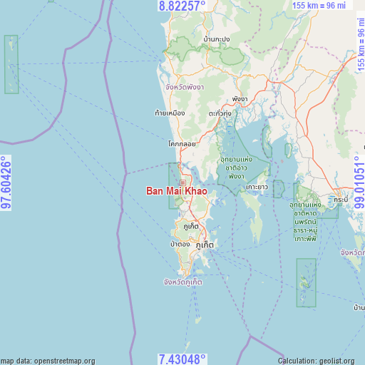
Ban Mai Khao GPS coordinates[2]
8° 7' 37.668" North, 98° 18' 26.568" East
| Map corner | latitude | longitude |
|---|---|---|
| Upper-left | 8.82257°, | 97.60426° |
| Center: | 8.12713°, | 98.30738° |
| Lower-right: | 7.43048°, | 99.01051° |
| Map W x H: | 154.8×154.8 km | = 96.2×96.2mi |
| max Lat: | 20.43353° ⇑88.5% North |
| Ban Mai Khao: | 8.12713° |
| min Lat: | ⇓11.5% South 5.77434° |
| min Long | Ban Mai Khao | max Long |
| 97.93288° | 98.30738° | 105.49506° |
| W 1.5%⇐ | ⇒98.5% E |
Elevation
Elevation of Ban Mai Khao is 15 m = 49 ft, and this is 110.5 m = 363 ft below average elevation for this country.
| Max E: |
1011 m = 3317 ft | 75.3% |
| Avg. | 125.5 m = 412 ft | |
| Ban Mai Khao | 15 m = 49 ft | |
Min E: |
1 m = 3 ft | 24.7% |
See also: Thailand elevation on elevation.city.
Geographical zone
Ban Mai Khao is located in North Torrid zone (between Equator and Tropic of Cancer). Distance of Equator is 903.7 km =561.5 mi to South.| Distance of | km | miles | from Ban Mai Khao |
|---|---|---|---|
| North Pole | 9103.4 | 5656.6 | to North |
| Arctic Circle | 6497.5 | 4037.4 | to North |
| Tropic Cancer | 1702.3 | 1057.8 | to North |
| Equator | 903.7 | 561.5 | to South |


Nearby cities:
15 places around Ban Mai Khao: (largest is in red/bold)
• Ban Chalong
31.6 km =19.6 mi,  173°
173°
• Ban Karon
31.1 km =19.3 mi,  181°
181°
• Ban Ko Kaeo
23.4 km =14.5 mi,  155°
155°
• Ban Ratsada
26.4 km =16.4 mi, 156°
• Ban Talat Nua
28.3 km =17.6 mi, 162°
• Ban Talat Yai
28.8 km =17.9 mi, 159°
• Kathu
23.4 km =14.5 mi, 173°
• Ko Yao
31.4 km =19.5 mi,  93°
93°
• Mueang Phuket
30 km =18.6 mi, 167°
• Patong
25.7 km =16 mi, 182°
• Phuket
28.1 km =17.5 mi, 159°
• Takua Thung
32.6 km =20.3 mi,  29°
29°
• Thai Mueang
30.7 km =19.1 mi,  350°
350°
• Thalang
11 km =6.8 mi, 164°
• Wichit
27.8 km =17.3 mi, 162°
Sources, notices
• [Note1] Compared only with cities in Thailand existing in our database
• [Src1] Map data: © OpenStreetMap contributors (CC-BY-SA)
• [Src2] Other city data from geonames.org with taken over terms of usage.
• [Src3] Geographical zone / Annual Mean Temperature by Robert A. Rohde @ Wikipedia
