Kathu geodata
Kathu (Phuket) is a populated place; located in Thailand in Asia/Bangkok (GMT+7) time zone. With population of 34,835 people, there are 94 cities with bigger population in this country. Compared to other cities in Thailand, 90.1% of cities are located further ↑North; 98.3% of cities are located further →East and 63.3% of cities have higher elevation than Kathu. Note1


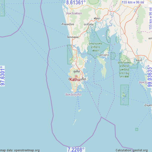
Kathu GPS coordinates[2]
7° 55' 4.044" North, 98° 19' 59.592" East
| Map corner | latitude | longitude |
|---|---|---|
| Upper-left | 8.61361°, | 97.6301° |
| Center: | 7.91779°, | 98.33322° |
| Lower-right: | 7.2208°, | 99.03635° |
| Map W x H: | 154.9×154.9 km | = 96.3×96.3mi |
| max Lat: | 20.43353° ⇑90.1% North |
| Kathu: | 7.91779° |
| min Lat: | ⇓9.9% South 5.77434° |
| min Long | Kathu | max Long |
| 97.93288° | 98.33322° | 105.49506° |
| W 1.7%⇐ | ⇒98.3% E |
Elevation
Elevation of Kathu is 36 m = 118 ft, and this is 89.5 m = 294 ft below average elevation for this country.
| Max E: |
1011 m = 3317 ft | 63.3% |
| Avg. | 125.5 m = 412 ft | |
| Kathu | 36 m = 118 ft | |
Min E: |
1 m = 3 ft | 36.7% |
See also: Thailand elevation on elevation.city.
Geographical zone
Kathu is located in North Torrid zone (between Equator and Tropic of Cancer). Distance of Equator is 880.4 km =547.1 mi to South.| Distance of | km | miles | from Kathu |
|---|---|---|---|
| North Pole | 9126.7 | 5671.1 | to North |
| Arctic Circle | 6520.8 | 4051.8 | to North |
| Tropic Cancer | 1725.5 | 1072.2 | to North |
| Equator | 880.4 | 547.1 | to South |


Nearby cities:
15 places around Kathu: (largest is in red/bold)
• Ban Chalong
8.2 km =5.1 mi,  175°
175°
• Ban Karon
8.7 km =5.4 mi,  206°
206°
• Ban Kata
11.1 km =6.9 mi,  195°
195°
• Ban Ko Kaeo
7.3 km =4.5 mi,  73°
73°
• Ban Mai Khao
23.4 km =14.5 mi,  353°
353°
• Ban Ratsada
7.7 km =4.8 mi,  96°
96°
• Ban Talat Nua
6.8 km =4.2 mi,  122°
122°
• Ban Talat Yai
8.2 km =5.1 mi, 116°
• Mueang Phuket
7 km =4.3 mi,  150°
150°
• Nai Harn
15.8 km =9.8 mi,  190°
190°
• Patong
4.7 km =2.9 mi,  239°
239°
• Phuket
7.8 km =4.8 mi,  112°
112°
• Rawai
15.4 km =9.6 mi, 183°
• Thalang
12.7 km =7.9 mi,  0°
0°
• Wichit
6.5 km =4 mi, 118°
Sources, notices
• [Note1] Compared only with cities in Thailand existing in our database
• [Src1] Map data: © OpenStreetMap contributors (CC-BY-SA)
• [Src2] Other city data from geonames.org with taken over terms of usage.
• [Src3] Geographical zone / Annual Mean Temperature by Robert A. Rohde @ Wikipedia
