Ban Chalong geodata
Ban Chalong (Phuket) is a populated place; located in Thailand in Asia/Bangkok (GMT+7) time zone. With population of 18,072 people, there are 175 cities with bigger population in this country. Compared to other cities in Thailand, 91% of cities are located further ↑North; 98.1% of cities are located further →East and 78.4% of cities have higher elevation than Ban Chalong. Note1


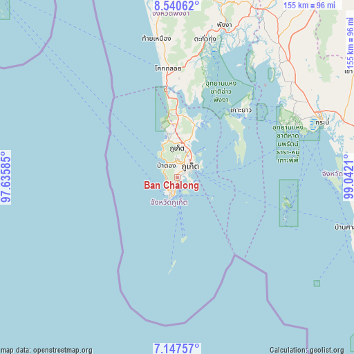
Ban Chalong GPS coordinates[2]
7° 50' 40.848" North, 98° 20' 20.292" East
| Map corner | latitude | longitude |
|---|---|---|
| Upper-left | 8.54062°, | 97.63585° |
| Center: | 7.84468°, | 98.33897° |
| Lower-right: | 7.14757°, | 99.0421° |
| Map W x H: | 154.9×154.9 km | = 96.3×96.3mi |
| max Lat: | 20.43353° ⇑91% North |
| Ban Chalong: | 7.84468° |
| min Lat: | ⇓9% South 5.77434° |
| min Long | Ban Chalong | max Long |
| 97.93288° | 98.33897° | 105.49506° |
| W 1.9%⇐ | ⇒98.1% E |
Elevation
Elevation of Ban Chalong is 13 m = 43 ft, and this is 112.5 m = 369 ft below average elevation for this country.
| Max E: |
1011 m = 3317 ft | 78.4% |
| Avg. | 125.5 m = 412 ft | |
| Ban Chalong | 13 m = 43 ft | |
Min E: |
1 m = 3 ft | 21.6% |
See also: Thailand elevation on elevation.city.
Geographical zone
Ban Chalong is located in North Torrid zone (between Equator and Tropic of Cancer). Distance of Equator is 872.2 km =542 mi to South.| Distance of | km | miles | from Ban Chalong |
|---|---|---|---|
| North Pole | 9134.8 | 5676.1 | to North |
| Arctic Circle | 6528.9 | 4056.9 | to North |
| Tropic Cancer | 1733.7 | 1077.3 | to North |
| Equator | 872.2 | 542 | to South |


Nearby cities:
15 places around Ban Chalong: (largest is in red/bold)
• Ban Karon
4.5 km =2.8 mi,  274°
274°
• Ban Kata
4.4 km =2.7 mi,  233°
233°
• Ban Ko Kaeo
12 km =7.5 mi,  32°
32°
• Ban Phru Nai
30.2 km =18.8 mi,  66°
66°
• Ban Ratsada
10.1 km =6.3 mi,  44°
44°
• Ban Talat Nua
6.8 km =4.2 mi,  48°
48°
• Ban Talat Yai
8.1 km =5 mi,  56°
56°
• Kathu
8.2 km =5.1 mi,  355°
355°
• Mueang Phuket
3.5 km =2.2 mi, 53°
• Nai Harn
8.2 km =5.1 mi,  205°
205°
• Patong
7.4 km =4.6 mi,  320°
320°
• Phuket
8.3 km =5.2 mi, 51°
• Rawai
7.4 km =4.6 mi,  191°
191°
• Thalang
20.8 km =12.9 mi, 358°
• Wichit
7.1 km =4.4 mi, 45°
Sources, notices
• [Note1] Compared only with cities in Thailand existing in our database
• [Src1] Map data: © OpenStreetMap contributors (CC-BY-SA)
• [Src2] Other city data from geonames.org with taken over terms of usage.
• [Src3] Geographical zone / Annual Mean Temperature by Robert A. Rohde @ Wikipedia
