Ban Ko Kaeo geodata
Ban Ko Kaeo (Phuket) is a populated place; located in Thailand in Asia/Bangkok (GMT+7) time zone. With population of 10,136 people, there are 283 cities with bigger population in this country. Compared to other cities in Thailand, 90% of cities are located further ↑North; 97.3% of cities are located further →East and 60.9% of cities have higher elevation than Ban Ko Kaeo. Note1


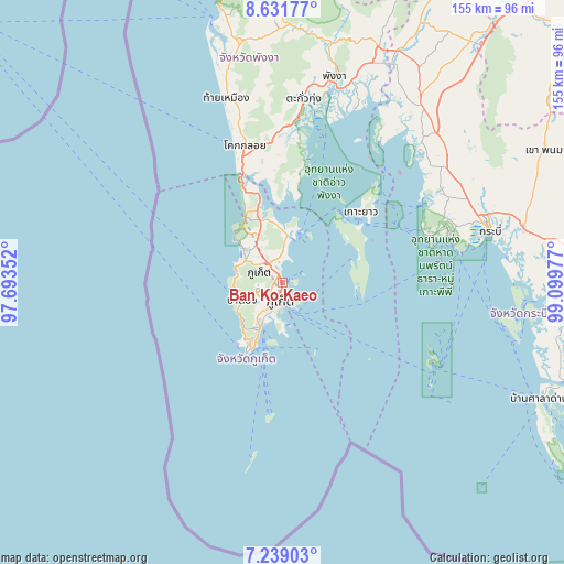
Ban Ko Kaeo GPS coordinates[2]
7° 56' 9.564" North, 98° 23' 47.904" East
| Map corner | latitude | longitude |
|---|---|---|
| Upper-left | 8.63177°, | 97.69352° |
| Center: | 7.93599°, | 98.39664° |
| Lower-right: | 7.23903°, | 99.09977° |
| Map W x H: | 154.9×154.9 km | = 96.3×96.3mi |
| max Lat: | 20.43353° ⇑90% North |
| Ban Ko Kaeo: | 7.93599° |
| min Lat: | ⇓10% South 5.77434° |
| min Long | Ban Ko Kaeo | max Long |
| 97.93288° | 98.39664° | 105.49506° |
| W 2.7%⇐ | ⇒97.3% E |
Elevation
Elevation of Ban Ko Kaeo is 42 m = 138 ft, and this is 83.5 m = 274 ft below average elevation for this country.
| Max E: |
1011 m = 3317 ft | 60.9% |
| Avg. | 125.5 m = 412 ft | |
| Ban Ko Kaeo | 42 m = 138 ft | |
Min E: |
1 m = 3 ft | 39.1% |
See also: Thailand elevation on elevation.city.
Geographical zone
Ban Ko Kaeo is located in North Torrid zone (between Equator and Tropic of Cancer). Distance of Equator is 882.4 km =548.3 mi to South.| Distance of | km | miles | from Ban Ko Kaeo |
|---|---|---|---|
| North Pole | 9124.7 | 5669.8 | to North |
| Arctic Circle | 6518.8 | 4050.6 | to North |
| Tropic Cancer | 1723.5 | 1070.9 | to North |
| Equator | 882.4 | 548.3 | to South |


Nearby cities:
15 places around Ban Ko Kaeo: (largest is in red/bold)
• Ban Chalong
12 km =7.5 mi,  212°
212°
• Ban Karon
14.6 km =9.1 mi,  227°
227°
• Ban Kata
16.1 km =10 mi,  217°
217°
• Ban Phru Nai
21.4 km =13.3 mi,  84°
84°
• Ban Ratsada
3 km =1.9 mi,  167°
167°
• Ban Talat Nua
5.8 km =3.6 mi,  192°
192°
• Ban Talat Yai
5.7 km =3.5 mi,  176°
176°
• Kathu
7.3 km =4.5 mi,  253°
253°
• Mueang Phuket
8.8 km =5.5 mi,  203°
203°
• Nai Harn
20.1 km =12.5 mi, 209°
• Patong
11.9 km =7.4 mi, 248°
• Phuket
5.1 km =3.2 mi, 178°
• Rawai
19.1 km =11.9 mi, 204°
• Thalang
12.7 km =7.9 mi,  327°
327°
• Wichit
5.3 km =3.3 mi, 193°
Sources, notices
• [Note1] Compared only with cities in Thailand existing in our database
• [Src1] Map data: © OpenStreetMap contributors (CC-BY-SA)
• [Src2] Other city data from geonames.org with taken over terms of usage.
• [Src3] Geographical zone / Annual Mean Temperature by Robert A. Rohde @ Wikipedia
