Thalang geodata
Thalang (Phuket) is a seat of a second-order administrative division; located in Thailand in Asia/Bangkok (GMT+7) time zone. In our database, there are 331 cities with bigger population. Compared to other cities in Thailand, 89.4% of cities are located further ↑North; 98.2% of cities are located further →East and 73.7% of cities have higher elevation than Thalang. Note1


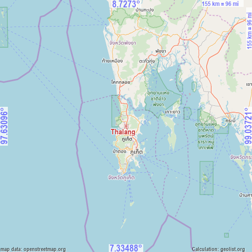
Thalang GPS coordinates[2]
8° 1' 54.084" North, 98° 20' 2.688" East
| Map corner | latitude | longitude |
|---|---|---|
| Upper-left | 8.7273°, | 97.63096° |
| Center: | 8.03169°, | 98.33408° |
| Lower-right: | 7.33488°, | 99.03721° |
| Map W x H: | 154.8×154.8 km | = 96.2×96.2mi |
| max Lat: | 20.43353° ⇑89.4% North |
| Thalang: | 8.03169° |
| min Lat: | ⇓10.6% South 5.77434° |
| min Long | Thalang | max Long |
| 97.93288° | 98.33408° | 105.49506° |
| W 1.8%⇐ | ⇒98.2% E |
Elevation
Elevation of Thalang is 16 m = 52 ft, and this is 109.5 m = 359 ft below average elevation for this country.
| Max E: |
1011 m = 3317 ft | 73.7% |
| Avg. | 125.5 m = 412 ft | |
| Thalang | 16 m = 52 ft | |
Min E: |
1 m = 3 ft | 26.3% |
See also: Thailand elevation on elevation.city.
Geographical zone
Thalang is located in North Torrid zone (between Equator and Tropic of Cancer). Distance of Equator is 893 km =554.9 mi to South.| Distance of | km | miles | from Thalang |
|---|---|---|---|
| North Pole | 9114 | 5663.2 | to North |
| Arctic Circle | 6508.1 | 4043.9 | to North |
| Tropic Cancer | 1712.9 | 1064.3 | to North |
| Equator | 893 | 554.9 | to South |


Nearby cities:
15 places around Thalang: (largest is in red/bold)
• Ban Chalong
20.8 km =12.9 mi,  178°
178°
• Ban Karon
20.8 km =12.9 mi,  190°
190°
• Ban Kata
23.6 km =14.7 mi, 187°
• Ban Ko Kaeo
12.7 km =7.9 mi,  147°
147°
• Ban Mai Khao
11 km =6.8 mi,  344°
344°
• Ban Ratsada
15.5 km =9.6 mi, 150°
• Ban Talat Nua
17.3 km =10.7 mi,  160°
160°
• Ban Talat Yai
17.9 km =11.1 mi, 156°
• Kathu
12.7 km =7.9 mi, 180°
• Mueang Phuket
19 km =11.8 mi,  169°
169°
• Nai Harn
28.3 km =17.6 mi, 186°
• Patong
15.6 km =9.7 mi,  195°
195°
• Phuket
17.2 km =10.7 mi, 155°
• Rawai
28 km =17.4 mi, 181°
• Wichit
16.8 km =10.4 mi, 160°
Sources, notices
• [Note1] Compared only with cities in Thailand existing in our database
• [Src1] Map data: © OpenStreetMap contributors (CC-BY-SA)
• [Src2] Other city data from geonames.org with taken over terms of usage.
• [Src3] Geographical zone / Annual Mean Temperature by Robert A. Rohde @ Wikipedia
