Wat Phleng geodata
Wat Phleng (Ratchaburi) is a seat of a second-order administrative division; located in Thailand in Asia/Bangkok (GMT+7) time zone. In our database, there are 331 cities with bigger population. Compared to other cities in Thailand, 75.4% of cities are located further ↑North; 76.3% of cities are located further →East and 94.4% of cities have higher elevation than Wat Phleng. Note1


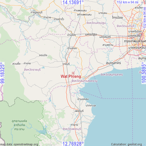
Wat Phleng GPS coordinates[2]
13° 27' 14.652" North, 99° 53' 10.932" East
| Map corner | latitude | longitude |
|---|---|---|
| Upper-left | 14.13691°, | 99.18325° |
| Center: | 13.45407°, | 99.88637° |
| Lower-right: | 12.76928°, | 100.5895° |
| Map W x H: | 152.1×152.1 km | = 94.5×94.5mi |
| max Lat: | 20.43353° ⇑75.4% North |
| Wat Phleng: | 13.45407° |
| min Lat: | ⇓24.6% South 5.77434° |
| min Long | Wat Phleng | max Long |
| 97.93288° | 99.88637° | 105.49506° |
| W 23.7%⇐ | ⇒76.3% E |
Elevation
Elevation of Wat Phleng is 7 m = 23 ft, and this is 118.5 m = 389 ft below average elevation for this country.
| Max E: |
1011 m = 3317 ft | 94.4% |
| Avg. | 125.5 m = 412 ft | |
| Wat Phleng | 7 m = 23 ft | |
Min E: |
1 m = 3 ft | 5.6% |
See also: Thailand elevation on elevation.city.
Geographical zone
Wat Phleng is located in North Torrid zone (between Equator and Tropic of Cancer). Distance of this Northern Tropic circle is 1110 km =689.7 mi to North.| Distance of | km | miles | from Wat Phleng |
|---|---|---|---|
| North Pole | 8511.1 | 5288.6 | to North |
| Arctic Circle | 5905.2 | 3669.3 | to North |
| Tropic Cancer | 1110 | 689.7 | to North |
| Equator | 1496 | 929.6 | to South |


Nearby cities:
15 places around Wat Phleng: (largest is in red/bold)
• Amphawa
8.3 km =5.2 mi,  113°
113°
• Ban Laem
29.5 km =18.3 mi,  160°
160°
• Ban Phaeo
28.3 km =17.6 mi,  57°
57°
• Ban Pong
40.3 km =25 mi,  358°
358°
• Bang Khon Thi
6.1 km =3.8 mi,  74°
74°
• Bang Phae
26.8 km =16.7 mi,  10°
10°
• Chom Bueng
36.8 km =22.9 mi,  300°
300°
• Damnoen Saduak
10.3 km =6.4 mi,  45°
45°
• Khao Yoi
24.7 km =15.3 mi,  195°
195°
• Nong Ya Plong
38.3 km =23.8 mi,  212°
212°
• Pak Tho
10.4 km =6.5 mi, 209°
• Phetchaburi
38.6 km =24 mi,  170°
170°
• Photharam
26.8 km =16.7 mi,  351°
351°
• Ratchaburi
11.9 km =7.4 mi,  320°
320°
• Samut Songkhram
13.3 km =8.3 mi, 109°
Sources, notices
• [Note1] Compared only with cities in Thailand existing in our database
• [Src1] Map data: © OpenStreetMap contributors (CC-BY-SA)
• [Src2] Other city data from geonames.org with taken over terms of usage.
• [Src3] Geographical zone / Annual Mean Temperature by Robert A. Rohde @ Wikipedia
