Bang Khon Thi geodata
Bang Khon Thi (Samut Songkhram) is a seat of a second-order administrative division; located in Thailand in Asia/Bangkok (GMT+7) time zone. In our database, there are 331 cities with bigger population. Compared to other cities in Thailand, 75.2% of cities are located further ↑North; 74.5% of cities are located further →East and 94.4% of cities have higher elevation than Bang Khon Thi. Note1


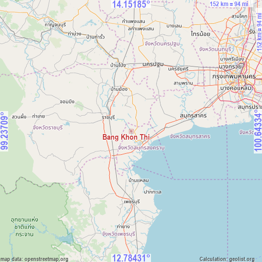
Bang Khon Thi GPS coordinates[2]
13° 28' 8.616" North, 99° 56' 24.756" East
| Map corner | latitude | longitude |
|---|---|---|
| Upper-left | 14.15185°, | 99.23709° |
| Center: | 13.46906°, | 99.94021° |
| Lower-right: | 12.78431°, | 100.64334° |
| Map W x H: | 152.1×152.1 km | = 94.5×94.5mi |
| max Lat: | 20.43353° ⇑75.2% North |
| Bang Khon Thi: | 13.46906° |
| min Lat: | ⇓24.8% South 5.77434° |
| min Long | Bang Khon Thi | max Long |
| 97.93288° | 99.94021° | 105.49506° |
| W 25.5%⇐ | ⇒74.5% E |
Elevation
Elevation of Bang Khon Thi is 7 m = 23 ft, and this is 118.5 m = 389 ft below average elevation for this country.
| Max E: |
1011 m = 3317 ft | 94.4% |
| Avg. | 125.5 m = 412 ft | |
| Bang Khon Thi | 7 m = 23 ft | |
Min E: |
1 m = 3 ft | 5.6% |
See also: Thailand elevation on elevation.city.
Geographical zone
Bang Khon Thi is located in North Torrid zone (between Equator and Tropic of Cancer). Distance of this Northern Tropic circle is 1108.3 km =688.7 mi to North.| Distance of | km | miles | from Bang Khon Thi |
|---|---|---|---|
| North Pole | 8509.4 | 5287.5 | to North |
| Arctic Circle | 5903.6 | 3668.3 | to North |
| Tropic Cancer | 1108.3 | 688.7 | to North |
| Equator | 1497.6 | 930.6 | to South |


Nearby cities:
15 places around Bang Khon Thi: (largest is in red/bold)
• Amphawa
5.3 km =3.3 mi,  160°
160°
• Ban Laem
29.7 km =18.5 mi,  171°
171°
• Ban Phaeo
22.6 km =14 mi,  53°
53°
• Ban Pong
39.2 km =24.4 mi,  350°
350°
• Bang Phae
24.8 km =15.4 mi,  357°
357°
• Damnoen Saduak
5.7 km =3.5 mi,  15°
15°
• Khao Yoi
28.4 km =17.6 mi,  206°
206°
• Krathum Baen
40.2 km =25 mi,  59°
59°
• Pak Tho
15.3 km =9.5 mi,  225°
225°
• Phetchaburi
39.7 km =24.7 mi,  179°
179°
• Photharam
26.7 km =16.6 mi,  338°
338°
• Ratchaburi
15.3 km =9.5 mi,  299°
299°
• Samut Sakhon
37.1 km =23.1 mi,  76°
76°
• Samut Songkhram
9.1 km =5.7 mi,  131°
131°
• Wat Phleng
6.1 km =3.8 mi,  254°
254°
Sources, notices
• [Note1] Compared only with cities in Thailand existing in our database
• [Src1] Map data: © OpenStreetMap contributors (CC-BY-SA)
• [Src2] Other city data from geonames.org with taken over terms of usage.
• [Src3] Geographical zone / Annual Mean Temperature by Robert A. Rohde @ Wikipedia
