Trat geodata
Trat is a seat of a first-order administrative division; located in Thailand in Asia/Bangkok (GMT+7) time zone. With population of 21,590 people, there are 149 cities with bigger population in this country. Compared to other cities in Thailand, 81% of cities are located further ↑North; 73.2% of cities are located further ←West and 94.4% of cities have higher elevation than Trat. Note1


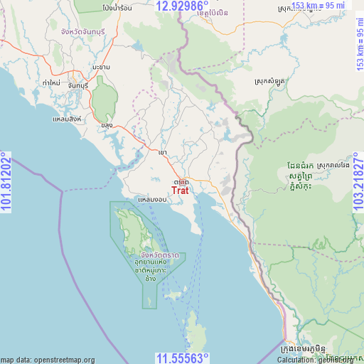
Trat GPS coordinates[2]
12° 14' 37.104" North, 102° 30' 54.504" East
| Map corner | latitude | longitude |
|---|---|---|
| Upper-left | 12.92986°, | 101.81202° |
| Center: | 12.24364°, | 102.51514° |
| Lower-right: | 11.55563°, | 103.21827° |
| Map W x H: | 152.8×152.8 km | = 94.9×94.9mi |
| max Lat: | 20.43353° ⇑81% North |
| Trat: | 12.24364° |
| min Lat: | ⇓19% South 5.77434° |
| min Long | Trat | max Long |
| 97.93288° | 102.51514° | 105.49506° |
| W 73.2%⇐ | ⇒26.8% E |
Elevation
Elevation of Trat is 7 m = 23 ft, and this is 118.5 m = 389 ft below average elevation for this country.
| Max E: |
1011 m = 3317 ft | 94.4% |
| Avg. | 125.5 m = 412 ft | |
| Trat | 7 m = 23 ft | |
Min E: |
1 m = 3 ft | 5.6% |
See also: Thailand elevation on elevation.city.
Geographical zone
Trat is located in North Torrid zone (between Equator and Tropic of Cancer). Distance of this Northern Tropic circle is 1244.6 km =773.4 mi to North.| Distance of | km | miles | from Trat |
|---|---|---|---|
| North Pole | 8645.7 | 5372.2 | to North |
| Arctic Circle | 6039.8 | 3753 | to North |
| Tropic Cancer | 1244.6 | 773.4 | to North |
| Equator | 1361.4 | 845.9 | to South |


Nearby cities:
15 places around Trat: (largest is in red/bold)
• Ban Bang Bao
37.4 km =23.2 mi,  216°
216°
• Bo Rai
36.7 km =22.8 mi,  3°
3°
• Chanthaburi
60.4 km =37.5 mi,  312°
312°
• Khao Khitchakut
76 km =47.2 mi,  325°
325°
• Khao Saming
15 km =9.3 mi,  324°
324°
• Khlong Yai
65.7 km =40.8 mi,  142°
142°
• Khlung
39.6 km =24.6 mi, 306°
• Ko Chang Tai
31 km =19.3 mi,  209°
209°
• Ko Kut
65.1 km =40.5 mi,  177°
177°
• Laem Ngop
15.3 km =9.5 mi,  238°
238°
• Laem Sing
54.8 km =34.1 mi,  298°
298°
• Makham
59 km =36.7 mi, 324°
• Na Yai Am
96.1 km =59.7 mi, 308°
• Pong Nam Ron
78.6 km =48.8 mi,  339°
339°
• Tha Mai
69.5 km =43.2 mi, 307°
Sources, notices
• [Note1] Compared only with cities in Thailand existing in our database
• [Src1] Map data: © OpenStreetMap contributors (CC-BY-SA)
• [Src2] Other city data from geonames.org with taken over terms of usage.
• [Src3] Geographical zone / Annual Mean Temperature by Robert A. Rohde @ Wikipedia
