Khlung geodata
Khlung (Chanthaburi) is a seat of a second-order administrative division; located in Thailand in Asia/Bangkok (GMT+7) time zone. With population of 13,286 people, there are 249 cities with bigger population in this country. Compared to other cities in Thailand, 80.6% of cities are located further ↑North; 69.5% of cities are located further ←West and 91.2% of cities have higher elevation than Khlung. Note1


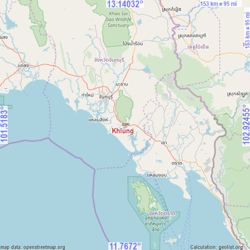
Khlung GPS coordinates[2]
12° 27' 16.812" North, 102° 13' 17.112" East
| Map corner | latitude | longitude |
|---|---|---|
| Upper-left | 13.14032°, | 101.5183° |
| Center: | 12.45467°, | 102.22142° |
| Lower-right: | 11.7672°, | 102.92455° |
| Map W x H: | 152.7×152.7 km | = 94.9×94.9mi |
| max Lat: | 20.43353° ⇑80.6% North |
| Khlung: | 12.45467° |
| min Lat: | ⇓19.4% South 5.77434° |
| min Long | Khlung | max Long |
| 97.93288° | 102.22142° | 105.49506° |
| W 69.5%⇐ | ⇒30.5% E |
Elevation
Elevation of Khlung is 8 m = 26 ft, and this is 117.5 m = 385 ft below average elevation for this country.
| Max E: |
1011 m = 3317 ft | 91.2% |
| Avg. | 125.5 m = 412 ft | |
| Khlung | 8 m = 26 ft | |
Min E: |
1 m = 3 ft | 8.8% |
See also: Thailand elevation on elevation.city.
Geographical zone
Khlung is located in North Torrid zone (between Equator and Tropic of Cancer). Distance of this Northern Tropic circle is 1221.1 km =758.8 mi to North.| Distance of | km | miles | from Khlung |
|---|---|---|---|
| North Pole | 8622.2 | 5357.6 | to North |
| Arctic Circle | 6016.3 | 3738.4 | to North |
| Tropic Cancer | 1221.1 | 758.8 | to North |
| Equator | 1384.8 | 860.5 | to South |


Nearby cities:
15 places around Khlung: (largest is in red/bold)
• Ban Bang Bao
54.5 km =33.9 mi,  169°
169°
• Bo Rai
36.7 km =22.8 mi,  69°
69°
• Chanthaburi
21.4 km =13.3 mi,  323°
323°
• Kaeng Hang Maeo
70.4 km =43.7 mi,  330°
330°
• Khao Khitchakut
40.6 km =25.2 mi,  343°
343°
• Khao Saming
25.8 km =16 mi,  115°
115°
• Klaeng
71.9 km =44.7 mi,  300°
300°
• Ko Chang Tai
53 km =32.9 mi,  161°
161°
• Laem Ngop
36.7 km =22.8 mi,  149°
149°
• Laem Sing
16.3 km =10.1 mi,  280°
280°
• Makham
24.4 km =15.2 mi,  353°
353°
• Na Yai Am
56.5 km =35.1 mi,  310°
310°
• Pong Nam Ron
50.4 km =31.3 mi,  5°
5°
• Tha Mai
29.9 km =18.6 mi, 308°
• Trat
39.6 km =24.6 mi,  126°
126°
Sources, notices
• [Note1] Compared only with cities in Thailand existing in our database
• [Src1] Map data: © OpenStreetMap contributors (CC-BY-SA)
• [Src2] Other city data from geonames.org with taken over terms of usage.
• [Src3] Geographical zone / Annual Mean Temperature by Robert A. Rohde @ Wikipedia
