Soeng Sang geodata
Soeng Sang (Nakhon Ratchasima) is a seat of a second-order administrative division; located in Thailand in Asia/Bangkok (GMT+7) time zone. With population of 14,138 people, there are 233 cities with bigger population in this country. Compared to other cities in Thailand, 60.7% of cities are located further ↑North; 72.7% of cities are located further ←West and 89% of cities have lower elevation than Soeng Sang. Note1


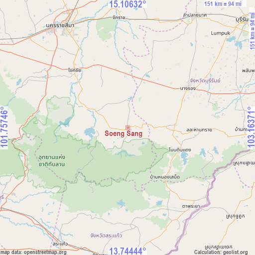
Soeng Sang GPS coordinates[2]
14° 25' 35.112" North, 102° 27' 38.088" East
| Map corner | latitude | longitude |
|---|---|---|
| Upper-left | 15.10632°, | 101.75746° |
| Center: | 14.42642°, | 102.46058° |
| Lower-right: | 13.74444°, | 103.16371° |
| Map W x H: | 151.4×151.4 km | = 94.1×94.1mi |
| max Lat: | 20.43353° ⇑60.7% North |
| Soeng Sang: | 14.42642° |
| min Lat: | ⇓39.3% South 5.77434° |
| min Long | Soeng Sang | max Long |
| 97.93288° | 102.46058° | 105.49506° |
| W 72.7%⇐ | ⇒27.3% E |
Elevation
Elevation of Soeng Sang is 266 m = 873 ft, and this is 140.5 m = 461 ft above average elevation for this country.
| Max E: |
1011 m = 3317 ft | 11% |
| Soeng Sang | 266 m 873 ft | |
| Avg. | 125.5 m = 412 ft | |
Min E: |
1 m = 3 ft | 89% |
See also: Thailand elevation on elevation.city.
Geographical zone
Soeng Sang is located in North Torrid zone (between Equator and Tropic of Cancer). Distance of this Northern Tropic circle is 1001.9 km =622.6 mi to North.| Distance of | km | miles | from Soeng Sang |
|---|---|---|---|
| North Pole | 8403 | 5221.4 | to North |
| Arctic Circle | 5797.1 | 3602.1 | to North |
| Tropic Cancer | 1001.9 | 622.6 | to North |
| Equator | 1604.1 | 996.7 | to South |


Nearby cities:
15 places around Soeng Sang: (largest is in red/bold)
• Chaloem Phra Kiat
52.1 km =32.4 mi,  73°
73°
• Chamni
55.9 km =34.7 mi,  44°
44°
• Chok Chai
46.2 km =28.7 mi,  316°
316°
• Khon Buri
25.6 km =15.9 mi,  295°
295°
• Lahan Sai
43 km =26.7 mi,  92°
92°
• Nang Rong
42.7 km =26.5 mi,  56°
56°
• Non Din Daeng
33.4 km =20.8 mi,  112°
112°
• Non Suwan
22.6 km =14 mi, 40°
• Nong Bun Nak
36.3 km =22.6 mi,  343°
343°
• Nong Hong
52.7 km =32.7 mi,  27°
27°
• Nong Ki
30.1 km =18.7 mi,  16°
16°
• Pa Kham
28.6 km =17.8 mi, 87°
• Pak Thong Chai
57.3 km =35.6 mi,  305°
305°
• Pakham
28.6 km =17.8 mi, 87°
• Ta Phraya
60 km =37.3 mi,  141°
141°
Sources, notices
• [Note1] Compared only with cities in Thailand existing in our database
• [Src1] Map data: © OpenStreetMap contributors (CC-BY-SA)
• [Src2] Other city data from geonames.org with taken over terms of usage.
• [Src3] Geographical zone / Annual Mean Temperature by Robert A. Rohde @ Wikipedia
