Pak Thong Chai geodata
Pak Thong Chai (Nakhon Ratchasima) is a seat of a second-order administrative division; located in Thailand in Asia/Bangkok (GMT+7) time zone. In our database, there are 331 cities with bigger population. Compared to other cities in Thailand, 55.3% of cities are located further ↑North; 66.9% of cities are located further ←West and 82.5% of cities have lower elevation than Pak Thong Chai. Note1


Pak Thong Chai GPS coordinates[2]
14° 43' 21.36" North, 102° 1' 30.432" East
| Map corner | latitude | longitude |
|---|---|---|
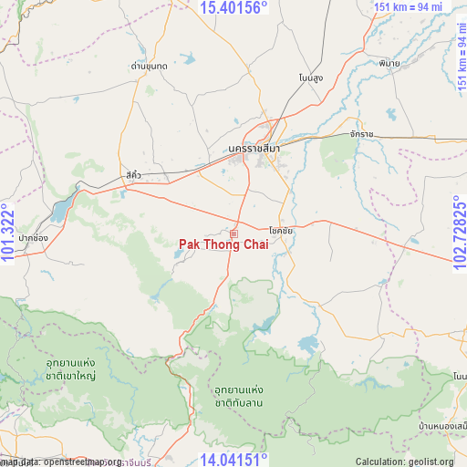
| Upper-left | 15.40156°, | 101.322° |
| Center: | 14.7226°, | 102.02512° |
| Lower-right: | 14.04151°, | 102.72825° |
| Map W x H: | 151.2×151.2 km | = 94×94mi |
| max Lat: | 20.43353° ⇑55.3% North |
| Pak Thong Chai: | 14.7226° |
| min Lat: | ⇓44.7% South 5.77434° |
| min Long | Pak Thong Chai | max Long |
| 97.93288° | 102.02512° | 105.49506° |
| W 66.9%⇐ | ⇒33.1% E |
Elevation
Elevation of Pak Thong Chai is 207 m = 679 ft, and this is 81.5 m = 267 ft above average elevation for this country.
| Max E: |
1011 m = 3317 ft | 17.5% |
| Pak Thong Chai | 207 m 679 ft | |
| Avg. | 125.5 m = 412 ft | |
Min E: |
1 m = 3 ft | 82.5% |
See also: Thailand elevation on elevation.city.
Geographical zone
Pak Thong Chai is located in North Torrid zone (between Equator and Tropic of Cancer). Distance of this Northern Tropic circle is 968.9 km =602 mi to North.| Distance of | km | miles | from Pak Thong Chai |
|---|---|---|---|
| North Pole | 8370.1 | 5200.9 | to North |
| Arctic Circle | 5764.2 | 3581.7 | to North |
| Tropic Cancer | 968.9 | 602 | to North |
| Equator | 1637 | 1017.2 | to South |


Nearby cities:
15 places around Pak Thong Chai: (largest is in red/bold)
• Amphoe Sikhiu
39.3 km =24.4 mi,  300°
300°
• Chakkarat
52.8 km =32.8 mi,  52°
52°
• Chaloem Phra Kiat
41 km =25.5 mi,  39°
39°
• Chok Chai
15.1 km =9.4 mi,  87°
87°
• Kham Thale So
27.8 km =17.3 mi,  342°
342°
• Khon Buri
32.3 km =20.1 mi,  132°
132°
• Nakhon Ratchasima
28.8 km =17.9 mi,  16°
16°
• Non Sung
56.6 km =35.2 mi,  26°
26°
• Non Thai
52.8 km =32.8 mi,  5°
5°
• Nong Bun Nak
36.7 km =22.8 mi, 87°
• Nong Ki
55.3 km =34.4 mi, 94°
• Sikhio
37.5 km =23.3 mi, 300°
• Soeng Sang
57.3 km =35.6 mi, 125°
• Sung Noen
29.5 km =18.3 mi,  311°
311°
• Wang Nam Khiao
38.2 km =23.7 mi,  207°
207°
Sources, notices
• [Note1] Compared only with cities in Thailand existing in our database
• [Src1] Map data: © OpenStreetMap contributors (CC-BY-SA)
• [Src2] Other city data from geonames.org with taken over terms of usage.
• [Src3] Geographical zone / Annual Mean Temperature by Robert A. Rohde @ Wikipedia
