Roi Et geodata
Roi Et is a seat of a first-order administrative division; located in Thailand in Asia/Bangkok (GMT+7) time zone. With population of 39,328 people, there are 79 cities with bigger population in this country. Compared to other cities in Thailand, 66.4% of cities are located further ↓South; 86.4% of cities are located further ←West and 60.1% of cities have lower elevation than Roi Et. Note1


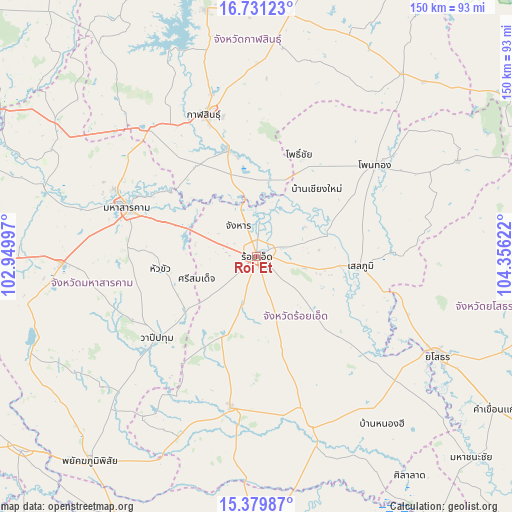
Roi Et GPS coordinates[2]
16° 3' 24.12" North, 103° 39' 11.124" East
| Map corner | latitude | longitude |
|---|---|---|
| Upper-left | 16.73123°, | 102.94997° |
| Center: | 16.0567°, | 103.65309° |
| Lower-right: | 15.37987°, | 104.35622° |
| Map W x H: | 150.3×150.3 km | = 93.4×93.4mi |
| max Lat: | 20.43353° ⇑33.6% North |
| Roi Et: | 16.0567° |
| min Lat: | ⇓66.4% South 5.77434° |
| min Long | Roi Et | max Long |
| 97.93288° | 103.65309° | 105.49506° |
| W 86.4%⇐ | ⇒13.6% E |
Elevation
Elevation of Roi Et is 148 m = 486 ft, and this is 22.5 m = 74 ft above average elevation for this country.
| Max E: |
1011 m = 3317 ft | 39.9% |
| Roi Et | 148 m 486 ft | |
| Avg. | 125.5 m = 412 ft | |
Min E: |
1 m = 3 ft | 60.1% |
See also: Thailand elevation on elevation.city.
Geographical zone
Roi Et is located in North Torrid zone (between Equator and Tropic of Cancer). Distance of this Northern Tropic circle is 820.6 km =509.9 mi to North.| Distance of | km | miles | from Roi Et |
|---|---|---|---|
| North Pole | 8221.7 | 5108.7 | to North |
| Arctic Circle | 5615.8 | 3489.5 | to North |
| Tropic Cancer | 820.6 | 509.9 | to North |
| Equator | 1785.3 | 1109.3 | to South |


Nearby cities:
15 places around Roi Et: (largest is in red/bold)
• At Samat
33.8 km =21 mi,  134°
134°
• Ban Selaphum
32 km =19.9 mi,  97°
97°
• Changhan
10.5 km =6.5 mi,  330°
330°
• Chaturaphak Phiman
25.6 km =15.9 mi,  203°
203°
• Chiang Khwan
16 km =9.9 mi,  42°
42°
• Kae Dam
28.9 km =18 mi,  262°
262°
• Kamalasai
32.4 km =20.1 mi,  345°
345°
• Khong Chai
30.7 km =19.1 mi,  317°
317°
• Mueang Suang
27.3 km =17 mi,  162°
162°
• Pho Chai
32.7 km =20.3 mi,  22°
22°
• Rong Kham
25.7 km =16 mi, 22°
• Selaphum
30.6 km =19 mi, 95°
• Si Somdet
18.8 km =11.7 mi,  249°
249°
• Thawat Buri
10.2 km =6.3 mi, 101°
• Thung Khao Luang
23.5 km =14.6 mi,  107°
107°
Sources, notices
• [Note1] Compared only with cities in Thailand existing in our database
• [Src1] Map data: © OpenStreetMap contributors (CC-BY-SA)
• [Src2] Other city data from geonames.org with taken over terms of usage.
• [Src3] Geographical zone / Annual Mean Temperature by Robert A. Rohde @ Wikipedia
