Prakhon Chai geodata
Prakhon Chai (Buriram) is a populated place; located in Thailand in Asia/Bangkok (GMT+7) time zone. With population of 15,564 people, there are 210 cities with bigger population in this country. Compared to other cities in Thailand, 57.7% of cities are located further ↑North; 80.7% of cities are located further ←West and 68.5% of cities have lower elevation than Prakhon Chai. Note1


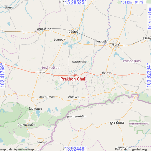
Prakhon Chai GPS coordinates[2]
14° 36' 21.312" North, 103° 7' 14.916" East
| Map corner | latitude | longitude |
|---|---|---|
| Upper-left | 15.28525°, | 102.41769° |
| Center: | 14.60592°, | 103.12081° |
| Lower-right: | 13.92448°, | 103.82394° |
| Map W x H: | 151.3×151.3 km | = 94×94mi |
| max Lat: | 20.43353° ⇑57.7% North |
| Prakhon Chai: | 14.60592° |
| min Lat: | ⇓42.3% South 5.77434° |
| min Long | Prakhon Chai | max Long |
| 97.93288° | 103.12081° | 105.49506° |
| W 80.7%⇐ | ⇒19.3% E |
Elevation
Elevation of Prakhon Chai is 166 m = 545 ft, and this is 40.5 m = 133 ft above average elevation for this country.
| Max E: |
1011 m = 3317 ft | 31.5% |
| Prakhon Chai | 166 m 545 ft | |
| Avg. | 125.5 m = 412 ft | |
Min E: |
1 m = 3 ft | 68.5% |
See also: Thailand elevation on elevation.city.
Geographical zone
Prakhon Chai is located in North Torrid zone (between Equator and Tropic of Cancer). Distance of this Northern Tropic circle is 981.9 km =610.1 mi to North.| Distance of | km | miles | from Prakhon Chai |
|---|---|---|---|
| North Pole | 8383 | 5209 | to North |
| Arctic Circle | 5777.1 | 3589.7 | to North |
| Tropic Cancer | 981.9 | 610.1 | to North |
| Equator | 1624 | 1009.1 | to South |


Nearby cities:
15 places around Prakhon Chai: (largest is in red/bold)
• Ban Kruat
20.5 km =12.7 mi,  186°
186°
• Buri Ram
43.2 km =26.8 mi,  357°
357°
• Chaloem Phra Kiat
21.7 km =13.5 mi,  255°
255°
• Chamni
37.8 km =23.5 mi,  302°
302°
• Huai Rat
40.1 km =24.9 mi,  10°
10°
• Krasang
40.4 km =25.1 mi,  29°
29°
• Lahan Sai
35.5 km =22.1 mi,  232°
232°
• Nang Rong
35.6 km =22.1 mi,  275°
275°
• Pa Kham
46.5 km =28.9 mi,  246°
246°
• Pakham
46.5 km =28.9 mi, 246°
• Phanom Dong Rak
26.7 km =16.6 mi,  131°
131°
• Phlapphla Chai
14.7 km =9.1 mi,  19°
19°
• Prakhon Chai
4.5 km =2.8 mi, 276°
• Prasat
30.8 km =19.1 mi,  82°
82°
• Surin
50.5 km =31.4 mi,  52°
52°
Sources, notices
• [Note1] Compared only with cities in Thailand existing in our database
• [Src1] Map data: © OpenStreetMap contributors (CC-BY-SA)
• [Src2] Other city data from geonames.org with taken over terms of usage.
• [Src3] Geographical zone / Annual Mean Temperature by Robert A. Rohde @ Wikipedia
