Huai Rat geodata
Huai Rat (Buriram) is a seat of a second-order administrative division; located in Thailand in Asia/Bangkok (GMT+7) time zone. In our database, there are 331 cities with bigger population. Compared to other cities in Thailand, 50.7% of cities are located further ↑North; 81.5% of cities are located further ←West and 66.2% of cities have lower elevation than Huai Rat. Note1


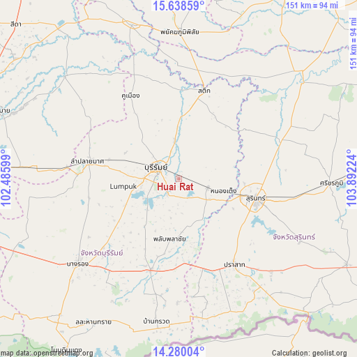
Huai Rat GPS coordinates[2]
14° 57' 37.404" North, 103° 11' 20.796" East
| Map corner | latitude | longitude |
|---|---|---|
| Upper-left | 15.63859°, | 102.48599° |
| Center: | 14.96039°, | 103.18911° |
| Lower-right: | 14.28004°, | 103.89224° |
| Map W x H: | 151.1×151.1 km | = 93.9×93.9mi |
| max Lat: | 20.43353° ⇑50.7% North |
| Huai Rat: | 14.96039° |
| min Lat: | ⇓49.3% South 5.77434° |
| min Long | Huai Rat | max Long |
| 97.93288° | 103.18911° | 105.49506° |
| W 81.5%⇐ | ⇒18.5% E |
Elevation
Elevation of Huai Rat is 162 m = 531 ft, and this is 36.5 m = 120 ft above average elevation for this country.
| Max E: |
1011 m = 3317 ft | 33.8% |
| Huai Rat | 162 m 531 ft | |
| Avg. | 125.5 m = 412 ft | |
Min E: |
1 m = 3 ft | 66.2% |
See also: Thailand elevation on elevation.city.
Geographical zone
Huai Rat is located in North Torrid zone (between Equator and Tropic of Cancer). Distance of this Northern Tropic circle is 942.5 km =585.6 mi to North.| Distance of | km | miles | from Huai Rat |
|---|---|---|---|
| North Pole | 8343.6 | 5184.5 | to North |
| Arctic Circle | 5737.7 | 3565.2 | to North |
| Tropic Cancer | 942.5 | 585.6 | to North |
| Equator | 1663.4 | 1033.6 | to South |


Nearby cities:
15 places around Huai Rat: (largest is in red/bold)
• Ban Dan
16.5 km =10.3 mi,  354°
354°
• Buri Ram
9.9 km =6.2 mi,  292°
292°
• Chamni
43.9 km =27.3 mi,  243°
243°
• Chom Phra
48.2 km =30 mi,  68°
68°
• Khaen Dong
41 km =25.5 mi, 351°
• Khu Mueang
40 km =24.9 mi,  329°
329°
• Khwao Sinarin
43.5 km =27 mi,  83°
83°
• Krasang
13 km =8.1 mi,  108°
108°
• Lam Plai Mat
38.3 km =23.8 mi,  280°
280°
• Phlapphla Chai
25.7 km =16 mi,  185°
185°
• Prakhon Chai
40.1 km =24.9 mi, 190°
• Prakhon Chai
40.6 km =25.2 mi,  196°
196°
• Prasat
42.4 km =26.3 mi,  146°
146°
• Satuek
39 km =24.2 mi,  16°
16°
• Surin
33.9 km =21.1 mi,  104°
104°
Sources, notices
• [Note1] Compared only with cities in Thailand existing in our database
• [Src1] Map data: © OpenStreetMap contributors (CC-BY-SA)
• [Src2] Other city data from geonames.org with taken over terms of usage.
• [Src3] Geographical zone / Annual Mean Temperature by Robert A. Rohde @ Wikipedia
