Phu Khiao geodata
Phu Khiao (Chaiyaphum) is a seat of a second-order administrative division; located in Thailand in Asia/Bangkok (GMT+7) time zone. With population of 17,122 people, there are 186 cities with bigger population in this country. Compared to other cities in Thailand, 70.4% of cities are located further ↓South; 68.3% of cities are located further ←West and 84.2% of cities have lower elevation than Phu Khiao. Note1


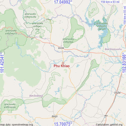
Phu Khiao GPS coordinates[2]
16° 22' 35.4" North, 102° 7' 42.708" East
| Map corner | latitude | longitude |
|---|---|---|
| Upper-left | 17.04992°, | 101.42541° |
| Center: | 16.3765°, | 102.12853° |
| Lower-right: | 15.70075°, | 102.83166° |
| Map W x H: | 150×150 km | = 93.2×93.2mi |
| max Lat: | 20.43353° ⇑29.6% North |
| Phu Khiao: | 16.3765° |
| min Lat: | ⇓70.4% South 5.77434° |
| min Long | Phu Khiao | max Long |
| 97.93288° | 102.12853° | 105.49506° |
| W 68.3%⇐ | ⇒31.7% E |
Elevation
Elevation of Phu Khiao is 213 m = 699 ft, and this is 87.5 m = 287 ft above average elevation for this country.
| Max E: |
1011 m = 3317 ft | 15.8% |
| Phu Khiao | 213 m 699 ft | |
| Avg. | 125.5 m = 412 ft | |
Min E: |
1 m = 3 ft | 84.2% |
See also: Thailand elevation on elevation.city.
Geographical zone
Phu Khiao is located in North Torrid zone (between Equator and Tropic of Cancer). Distance of this Northern Tropic circle is 785 km =487.8 mi to North.| Distance of | km | miles | from Phu Khiao |
|---|---|---|---|
| North Pole | 8186.2 | 5086.7 | to North |
| Arctic Circle | 5580.3 | 3467.4 | to North |
| Tropic Cancer | 785 | 487.8 | to North |
| Equator | 1820.9 | 1131.5 | to South |


Nearby cities:
15 places around Phu Khiao: (largest is in red/bold)
• Ban Thaen
23 km =14.3 mi,  82°
82°
• Chum Phae
18.9 km =11.7 mi,  350°
350°
• Kaeng Khro
32.8 km =20.4 mi,  155°
155°
• Kaset Sombun
21.4 km =13.3 mi,  240°
240°
• Khok Pho Chai
43.5 km =27 mi,  138°
138°
• Khon San
34.5 km =21.4 mi,  319°
319°
• Khon Sawan
52 km =32.3 mi, 161°
• Mancha Khiri
51.5 km =32 mi,  122°
122°
• Nong Bua Daeng
48 km =29.8 mi,  226°
226°
• Nong Na Kham
52.5 km =32.6 mi,  24°
24°
• Nong Ruea
35 km =21.7 mi,  68°
68°
• Phu Pha Man
38.8 km =24.1 mi, 321°
• Phu Wiang
40.4 km =25.1 mi,  40°
40°
• Si Chomphu
47.3 km =29.4 mi,  7°
7°
• Wiang Kao
37.9 km =23.5 mi,  26°
26°
Sources, notices
• [Note1] Compared only with cities in Thailand existing in our database
• [Src1] Map data: © OpenStreetMap contributors (CC-BY-SA)
• [Src2] Other city data from geonames.org with taken over terms of usage.
• [Src3] Geographical zone / Annual Mean Temperature by Robert A. Rohde @ Wikipedia
