Kaeng Khro geodata
Kaeng Khro (Chaiyaphum) is a seat of a second-order administrative division; located in Thailand in Asia/Bangkok (GMT+7) time zone. With population of 29,056 people, there are 111 cities with bigger population in this country. Compared to other cities in Thailand, 67.5% of cities are located further ↓South; 69.9% of cities are located further ←West and 82.2% of cities have lower elevation than Kaeng Khro. Note1


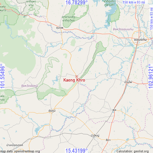
Kaeng Khro GPS coordinates[2]
16° 6' 31.104" North, 102° 15' 29.088" East
| Map corner | latitude | longitude |
|---|---|---|
| Upper-left | 16.78299°, | 101.55496° |
| Center: | 16.10864°, | 102.25808° |
| Lower-right: | 15.43199°, | 102.96121° |
| Map W x H: | 150.2×150.2 km | = 93.3×93.3mi |
| max Lat: | 20.43353° ⇑32.5% North |
| Kaeng Khro: | 16.10864° |
| min Lat: | ⇓67.5% South 5.77434° |
| min Long | Kaeng Khro | max Long |
| 97.93288° | 102.25808° | 105.49506° |
| W 69.9%⇐ | ⇒30.1% E |
Elevation
Elevation of Kaeng Khro is 205 m = 673 ft, and this is 79.5 m = 261 ft above average elevation for this country.
| Max E: |
1011 m = 3317 ft | 17.8% |
| Kaeng Khro | 205 m 673 ft | |
| Avg. | 125.5 m = 412 ft | |
Min E: |
1 m = 3 ft | 82.2% |
See also: Thailand elevation on elevation.city.
Geographical zone
Kaeng Khro is located in North Torrid zone (between Equator and Tropic of Cancer). Distance of this Northern Tropic circle is 814.8 km =506.3 mi to North.| Distance of | km | miles | from Kaeng Khro |
|---|---|---|---|
| North Pole | 8215.9 | 5105.1 | to North |
| Arctic Circle | 5610.1 | 3486 | to North |
| Tropic Cancer | 814.8 | 506.3 | to North |
| Equator | 1791.1 | 1112.9 | to South |


Nearby cities:
15 places around Kaeng Khro: (largest is in red/bold)
• Ban Thaen
34.2 km =21.3 mi,  15°
15°
• Chaiyaphum
41.2 km =25.6 mi,  216°
216°
• Chonnabot
38.9 km =24.2 mi,  93°
93°
• Kaeng Sanam Nang
39.9 km =24.8 mi,  180°
180°
• Kaset Sombun
37.7 km =23.4 mi,  300°
300°
• Khok Pho Chai
15.3 km =9.5 mi,  100°
100°
• Khon Sawan
19.8 km =12.3 mi,  172°
172°
• Mancha Khiri
29.9 km =18.6 mi, 85°
• Non Sila
46.5 km =28.9 mi,  108°
108°
• Nong Bua Daeng
48.8 km =30.3 mi,  266°
266°
• Nong Ruea
46.7 km =29 mi, 23°
• Phra Yuen
48.7 km =30.3 mi,  59°
59°
• Phu Khiao
32.8 km =20.4 mi,  335°
335°
• Waeng Noi
37.9 km =23.5 mi,  153°
153°
• Waeng Yai
35.3 km =21.9 mi,  118°
118°
Sources, notices
• [Note1] Compared only with cities in Thailand existing in our database
• [Src1] Map data: © OpenStreetMap contributors (CC-BY-SA)
• [Src2] Other city data from geonames.org with taken over terms of usage.
• [Src3] Geographical zone / Annual Mean Temperature by Robert A. Rohde @ Wikipedia
