Kaset Sombun geodata
Kaset Sombun (Chaiyaphum) is a seat of a second-order administrative division; located in Thailand in Asia/Bangkok (GMT+7) time zone. With population of 16,996 people, there are 189 cities with bigger population in this country. Compared to other cities in Thailand, 69.3% of cities are located further ↓South; 66.4% of cities are located further ←West and 87.1% of cities have lower elevation than Kaset Sombun. Note1


Kaset Sombun GPS coordinates[2]
16° 16' 49.908" North, 101° 57' 15.192" East
| Map corner | latitude | longitude |
|---|---|---|
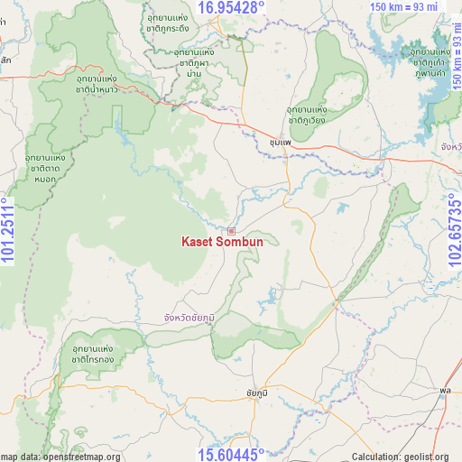
| Upper-left | 16.95428°, | 101.2511° |
| Center: | 16.28053°, | 101.95422° |
| Lower-right: | 15.60445°, | 102.65735° |
| Map W x H: | 150.1×150.1 km | = 93.3×93.3mi |
| max Lat: | 20.43353° ⇑30.7% North |
| Kaset Sombun: | 16.28053° |
| min Lat: | ⇓69.3% South 5.77434° |
| min Long | Kaset Sombun | max Long |
| 97.93288° | 101.95422° | 105.49506° |
| W 66.4%⇐ | ⇒33.6% E |
Elevation
Elevation of Kaset Sombun is 234 m = 768 ft, and this is 108.5 m = 356 ft above average elevation for this country.
| Max E: |
1011 m = 3317 ft | 12.9% |
| Kaset Sombun | 234 m 768 ft | |
| Avg. | 125.5 m = 412 ft | |
Min E: |
1 m = 3 ft | 87.1% |
See also: Thailand elevation on elevation.city.
Geographical zone
Kaset Sombun is located in North Torrid zone (between Equator and Tropic of Cancer). Distance of this Northern Tropic circle is 795.7 km =494.4 mi to North.| Distance of | km | miles | from Kaset Sombun |
|---|---|---|---|
| North Pole | 8196.8 | 5093.3 | to North |
| Arctic Circle | 5590.9 | 3474 | to North |
| Tropic Cancer | 795.7 | 494.4 | to North |
| Equator | 1810.2 | 1124.8 | to South |


Nearby cities:
15 places around Kaset Sombun: (largest is in red/bold)
• Ban Khwao
56.1 km =34.9 mi,  185°
185°
• Ban Thaen
43.7 km =27.2 mi,  71°
71°
• Chaiyaphum
52.9 km =32.9 mi,  171°
171°
• Chum Phae
33.2 km =20.6 mi,  27°
27°
• Kaeng Khro
37.7 km =23.4 mi,  120°
120°
• Khok Pho Chai
52.3 km =32.5 mi,  114°
114°
• Khon San
37.1 km =23.1 mi,  354°
354°
• Khon Sawan
52.2 km =32.4 mi,  137°
137°
• Nong Bua Daeng
27.6 km =17.1 mi,  216°
216°
• Nong Bua Rawe
62.1 km =38.6 mi,  199°
199°
• Nong Ruea
56.3 km =35 mi, 65°
• Phu Khiao
21.4 km =13.3 mi,  60°
60°
• Phu Pha Man
41.3 km =25.7 mi, 352°
• Phu Wiang
61.1 km =38 mi,  47°
47°
• Wiang Kao
56.9 km =35.4 mi,  38°
38°
Sources, notices
• [Note1] Compared only with cities in Thailand existing in our database
• [Src1] Map data: © OpenStreetMap contributors (CC-BY-SA)
• [Src2] Other city data from geonames.org with taken over terms of usage.
• [Src3] Geographical zone / Annual Mean Temperature by Robert A. Rohde @ Wikipedia
