Bang Rak geodata
Bang Rak (Bangkok) is a seat of a second-order administrative division; located in Thailand in Asia/Bangkok (GMT+7) time zone. In our database, there are 331 cities with bigger population. Compared to other cities in Thailand, 70.5% of cities are located further ↑North; 57% of cities are located further →East and 83.5% of cities have higher elevation than Bang Rak. Note1


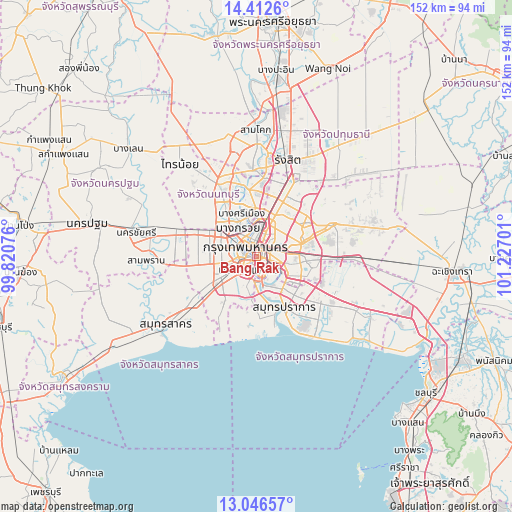
Bang Rak GPS coordinates[2]
13° 43' 50.088" North, 100° 31' 25.968" East
| Map corner | latitude | longitude |
|---|---|---|
| Upper-left | 14.4126°, | 99.82076° |
| Center: | 13.73058°, | 100.52388° |
| Lower-right: | 13.04657°, | 101.22701° |
| Map W x H: | 151.9×151.9 km | = 94.4×94.4mi |
| max Lat: | 20.43353° ⇑70.5% North |
| Bang Rak: | 13.73058° |
| min Lat: | ⇓29.5% South 5.77434° |
| min Long | Bang Rak | max Long |
| 97.93288° | 100.52388° | 105.49506° |
| W 43%⇐ | ⇒57% E |
Elevation
Elevation of Bang Rak is 11 m = 36 ft, and this is 114.5 m = 376 ft below average elevation for this country.
| Max E: |
1011 m = 3317 ft | 83.5% |
| Avg. | 125.5 m = 412 ft | |
| Bang Rak | 11 m = 36 ft | |
Min E: |
1 m = 3 ft | 16.5% |
See also: Thailand elevation on elevation.city.
Geographical zone
Bang Rak is located in North Torrid zone (between Equator and Tropic of Cancer). Distance of this Northern Tropic circle is 1079.2 km =670.6 mi to North.| Distance of | km | miles | from Bang Rak |
|---|---|---|---|
| North Pole | 8480.4 | 5269.5 | to North |
| Arctic Circle | 5874.5 | 3650.2 | to North |
| Tropic Cancer | 1079.2 | 670.6 | to North |
| Equator | 1526.7 | 948.6 | to South |


Nearby cities:
15 places around Bang Rak: (largest is in red/bold)
• Bang Kho Laem
4.7 km =2.9 mi,  209°
209°
• Bangkok
3.6 km =2.2 mi,  317°
317°
• Bangkok Yai
5.2 km =3.2 mi,  260°
260°
• Din Daeng
5.4 km =3.4 mi,  35°
35°
• Dusit
5.2 km =3.2 mi,  355°
355°
• Khlong San
1.6 km =1 mi,  271°
271°
• Khlong Toei
5.4 km =3.4 mi,  106°
106°
• Pathum Wan
0.7 km =0.4 mi,  0°
0°
• Phra Nakhon
4.7 km =2.9 mi, 324°
• Pom Prap Sattru Phai
3.3 km =2.1 mi,  339°
339°
• Ratchathewi
3.3 km =2.1 mi,  18°
18°
• Samphanthawong
1.1 km =0.7 mi,  275°
275°
• Sathon
2.5 km =1.6 mi,  174°
174°
• Thon Buri
4.2 km =2.6 mi, 261°
• Yan Nawa
4.3 km =2.7 mi,  152°
152°
Sources, notices
• [Note1] Compared only with cities in Thailand existing in our database
• [Src1] Map data: © OpenStreetMap contributors (CC-BY-SA)
• [Src2] Other city data from geonames.org with taken over terms of usage.
• [Src3] Geographical zone / Annual Mean Temperature by Robert A. Rohde @ Wikipedia
