Sathon geodata
Sathon (Bangkok) is a seat of a second-order administrative division; located in Thailand in Asia/Bangkok (GMT+7) time zone. In our database, there are 331 cities with bigger population. Compared to other cities in Thailand, 71.5% of cities are located further ↑North; 56.8% of cities are located further →East and 83.5% of cities have higher elevation than Sathon. Note1


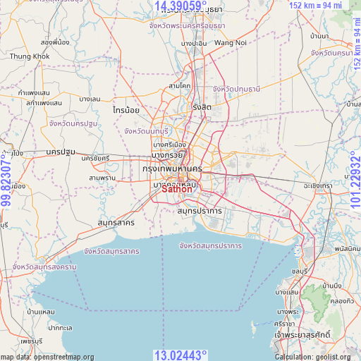
Sathon GPS coordinates[2]
13° 42' 30.6" North, 100° 31' 34.284" East
| Map corner | latitude | longitude |
|---|---|---|
| Upper-left | 14.39059°, | 99.82307° |
| Center: | 13.7085°, | 100.52619° |
| Lower-right: | 13.02443°, | 101.22932° |
| Map W x H: | 151.9×151.9 km | = 94.4×94.4mi |
| max Lat: | 20.43353° ⇑71.5% North |
| Sathon: | 13.7085° |
| min Lat: | ⇓28.5% South 5.77434° |
| min Long | Sathon | max Long |
| 97.93288° | 100.52619° | 105.49506° |
| W 43.2%⇐ | ⇒56.8% E |
Elevation
Elevation of Sathon is 11 m = 36 ft, and this is 114.5 m = 376 ft below average elevation for this country.
| Max E: |
1011 m = 3317 ft | 83.5% |
| Avg. | 125.5 m = 412 ft | |
| Sathon | 11 m = 36 ft | |
Min E: |
1 m = 3 ft | 16.5% |
See also: Thailand elevation on elevation.city.
Geographical zone
Sathon is located in North Torrid zone (between Equator and Tropic of Cancer). Distance of this Northern Tropic circle is 1081.7 km =672.1 mi to North.| Distance of | km | miles | from Sathon |
|---|---|---|---|
| North Pole | 8482.8 | 5271 | to North |
| Arctic Circle | 5876.9 | 3651.7 | to North |
| Tropic Cancer | 1081.7 | 672.1 | to North |
| Equator | 1524.2 | 947.1 | to South |


Nearby cities:
15 places around Sathon: (largest is in red/bold)
• Bang Kho Laem
3.1 km =1.9 mi,  237°
237°
• Bang Rak
2.5 km =1.6 mi,  354°
354°
• Bangkok
5.7 km =3.5 mi,  332°
332°
• Bangkok Yai
5.7 km =3.5 mi,  286°
286°
• Chom Thong
5.7 km =3.5 mi,  232°
232°
• Khlong San
3.1 km =1.9 mi,  323°
323°
• Khlong Toei
5 km =3.1 mi,  79°
79°
• Pathum Wan
3.1 km =1.9 mi,  355°
355°
• Phra Pradaeng
5.6 km =3.5 mi,  171°
171°
• Pom Prap Sattru Phai
5.7 km =3.5 mi, 345°
• Rat Burana
3.6 km =2.2 mi,  216°
216°
• Ratchathewi
5.7 km =3.5 mi,  8°
8°
• Samphanthawong
2.9 km =1.8 mi, 332°
• Thon Buri
4.8 km =3 mi, 292°
• Yan Nawa
2.2 km =1.4 mi,  128°
128°
Sources, notices
• [Note1] Compared only with cities in Thailand existing in our database
• [Src1] Map data: © OpenStreetMap contributors (CC-BY-SA)
• [Src2] Other city data from geonames.org with taken over terms of usage.
• [Src3] Geographical zone / Annual Mean Temperature by Robert A. Rohde @ Wikipedia
