Phanom Sarakham geodata
Phanom Sarakham (Chachoengsao) is a seat of a second-order administrative division; located in Thailand in Asia/Bangkok (GMT+7) time zone. With population of 16,057 people, there are 203 cities with bigger population in this country. Compared to other cities in Thailand, 70% of cities are located further ↑North; 59.5% of cities are located further ←West and 91.2% of cities have higher elevation than Phanom Sarakham. Note1


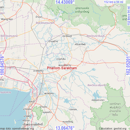
Phanom Sarakham GPS coordinates[2]
13° 44' 55.392" North, 101° 20' 55.968" East
| Map corner | latitude | longitude |
|---|---|---|
| Upper-left | 14.43069°, | 100.64576° |
| Center: | 13.74872°, | 101.34888° |
| Lower-right: | 13.06476°, | 102.05201° |
| Map W x H: | 151.9×151.9 km | = 94.4×94.4mi |
| max Lat: | 20.43353° ⇑70% North |
| Phanom Sarakham: | 13.74872° |
| min Lat: | ⇓30% South 5.77434° |
| min Long | Phanom Sarakham | max Long |
| 97.93288° | 101.34888° | 105.49506° |
| W 59.5%⇐ | ⇒40.5% E |
Elevation
Elevation of Phanom Sarakham is 8 m = 26 ft, and this is 117.5 m = 385 ft below average elevation for this country.
| Max E: |
1011 m = 3317 ft | 91.2% |
| Avg. | 125.5 m = 412 ft | |
| Phanom Sarakham | 8 m = 26 ft | |
Min E: |
1 m = 3 ft | 8.8% |
See also: Thailand elevation on elevation.city.
Geographical zone
Phanom Sarakham is located in North Torrid zone (between Equator and Tropic of Cancer). Distance of this Northern Tropic circle is 1077.2 km =669.3 mi to North.| Distance of | km | miles | from Phanom Sarakham |
|---|---|---|---|
| North Pole | 8478.3 | 5268.2 | to North |
| Arctic Circle | 5872.5 | 3649 | to North |
| Tropic Cancer | 1077.2 | 669.3 | to North |
| Equator | 1528.7 | 949.9 | to South |


Nearby cities:
15 places around Phanom Sarakham: (largest is in red/bold)
• Ban Pho
33.5 km =20.8 mi,  240°
240°
• Ban Sang
30.7 km =19.1 mi,  333°
333°
• Bang Khla
15.5 km =9.6 mi,  258°
258°
• Bang Nam Priao
33.8 km =21 mi,  288°
288°
• Chachoengsao
30.7 km =19.1 mi, 257°
• Khlong Khuean
20.6 km =12.8 mi,  283°
283°
• Ko Chan
37 km =23 mi,  182°
182°
• Phanat Nikhom
38.1 km =23.7 mi,  207°
207°
• Plaeng Yao
19.5 km =12.1 mi,  201°
201°
• Prachamtakham
39.4 km =24.5 mi,  27°
27°
• Prachin Buri
33.6 km =20.9 mi,  3°
3°
• Ratchasan
8.2 km =5.1 mi,  296°
296°
• Sanam Chai Khet
14 km =8.7 mi,  135°
135°
• Si Maha Phot
30 km =18.6 mi,  36°
36°
• Si Mahosot
16.6 km =10.3 mi,  21°
21°
Sources, notices
• [Note1] Compared only with cities in Thailand existing in our database
• [Src1] Map data: © OpenStreetMap contributors (CC-BY-SA)
• [Src2] Other city data from geonames.org with taken over terms of usage.
• [Src3] Geographical zone / Annual Mean Temperature by Robert A. Rohde @ Wikipedia
