Chachoengsao geodata
Chachoengsao is a seat of a first-order administrative division; located in Thailand in Asia/Bangkok (GMT+7) time zone. With population of 49,741 people, there are 56 cities with bigger population in this country. Compared to other cities in Thailand, 72.5% of cities are located further ↑North; 55.5% of cities are located further ←West and 99.3% of cities have higher elevation than Chachoengsao. Note1


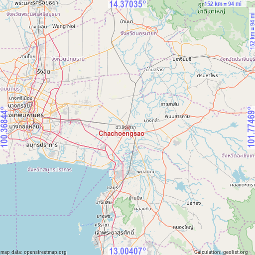
Chachoengsao GPS coordinates[2]
13° 41' 17.52" North, 101° 4' 17.616" East
| Map corner | latitude | longitude |
|---|---|---|
| Upper-left | 14.37035°, | 100.36844° |
| Center: | 13.6882°, | 101.07156° |
| Lower-right: | 13.00407°, | 101.77469° |
| Map W x H: | 151.9×151.9 km | = 94.4×94.4mi |
| max Lat: | 20.43353° ⇑72.5% North |
| Chachoengsao: | 13.6882° |
| min Lat: | ⇓27.5% South 5.77434° |
| min Long | Chachoengsao | max Long |
| 97.93288° | 101.07156° | 105.49506° |
| W 55.5%⇐ | ⇒44.5% E |
Elevation
Elevation of Chachoengsao is 4 m = 13 ft, and this is 121.5 m = 399 ft below average elevation for this country.
| Max E: |
1011 m = 3317 ft | 99.3% |
| Avg. | 125.5 m = 412 ft | |
| Chachoengsao | 4 m = 13 ft | |
Min E: |
1 m = 3 ft | 0.7% |
See also: Chachoengsao elevation on elevation.city.
Geographical zone
Chachoengsao is located in North Torrid zone (between Equator and Tropic of Cancer). Distance of this Northern Tropic circle is 1083.9 km =673.5 mi to North.| Distance of | km | miles | from Chachoengsao |
|---|---|---|---|
| North Pole | 8485.1 | 5272.4 | to North |
| Arctic Circle | 5879.2 | 3653.2 | to North |
| Tropic Cancer | 1083.9 | 673.5 | to North |
| Equator | 1522 | 945.7 | to South |


Nearby cities:
15 places around Chachoengsao: (largest is in red/bold)
• Ban Khlong Bang Sao Thong
26.3 km =16.3 mi,  258°
258°
• Ban Pho
10 km =6.2 mi,  175°
175°
• Bang Bo
28.5 km =17.7 mi,  243°
243°
• Bang Bo District
29.9 km =18.6 mi,  247°
247°
• Bang Khla
15.2 km =9.4 mi,  75°
75°
• Bang Nam Priao
17.8 km =11.1 mi,  353°
353°
• Bang Pakong
18.2 km =11.3 mi,  207°
207°
• Bang Sao Thong
28 km =17.4 mi, 248°
• Khlong Khuean
15.2 km =9.4 mi,  40°
40°
• Nong Chok
29.3 km =18.2 mi,  309°
309°
• Phan Thong
24.6 km =15.3 mi,  174°
174°
• Phanat Nikhom
29.6 km =18.4 mi,  155°
155°
• Phanom Sarakham
30.7 km =19.1 mi, 77°
• Plaeng Yao
25.7 km =16 mi,  116°
116°
• Ratchasan
24.9 km =15.5 mi,  65°
65°
Sources, notices
• [Note1] Compared only with cities in Thailand existing in our database
• [Src1] Map data: © OpenStreetMap contributors (CC-BY-SA)
• [Src2] Other city data from geonames.org with taken over terms of usage.
• [Src3] Geographical zone / Annual Mean Temperature by Robert A. Rohde @ Wikipedia
