Thon Buri geodata
Thon Buri (Bangkok) is a seat of a second-order administrative division; located in Thailand in Asia/Bangkok (GMT+7) time zone. In our database, there are 331 cities with bigger population. Compared to other cities in Thailand, 70.9% of cities are located further ↑North; 58.9% of cities are located further →East and 94.4% of cities have higher elevation than Thon Buri. Note1


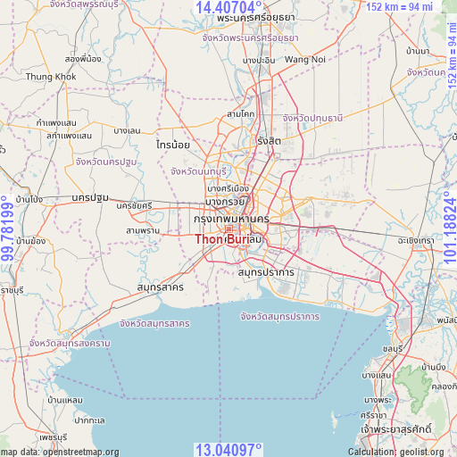
Thon Buri GPS coordinates[2]
13° 43' 30" North, 100° 29' 6.396" East
| Map corner | latitude | longitude |
|---|---|---|
| Upper-left | 14.40704°, | 99.78199° |
| Center: | 13.725°, | 100.48511° |
| Lower-right: | 13.04097°, | 101.18824° |
| Map W x H: | 151.9×151.9 km | = 94.4×94.4mi |
| max Lat: | 20.43353° ⇑70.9% North |
| Thon Buri: | 13.725° |
| min Lat: | ⇓29.1% South 5.77434° |
| min Long | Thon Buri | max Long |
| 97.93288° | 100.48511° | 105.49506° |
| W 41.1%⇐ | ⇒58.9% E |
Elevation
Elevation of Thon Buri is 7 m = 23 ft, and this is 118.5 m = 389 ft below average elevation for this country.
| Max E: |
1011 m = 3317 ft | 94.4% |
| Avg. | 125.5 m = 412 ft | |
| Thon Buri | 7 m = 23 ft | |
Min E: |
1 m = 3 ft | 5.6% |
See also: Thailand elevation on elevation.city.
Geographical zone
Thon Buri is located in North Torrid zone (between Equator and Tropic of Cancer). Distance of this Northern Tropic circle is 1079.8 km =671 mi to North.| Distance of | km | miles | from Thon Buri |
|---|---|---|---|
| North Pole | 8481 | 5269.8 | to North |
| Arctic Circle | 5875.1 | 3650.6 | to North |
| Tropic Cancer | 1079.8 | 671 | to North |
| Equator | 1526.1 | 948.3 | to South |


Nearby cities:
15 places around Thon Buri: (largest is in red/bold)
• Bang Kho Laem
4 km =2.5 mi,  152°
152°
• Bang Rak
4.2 km =2.6 mi,  81°
81°
• Bangkok
3.7 km =2.3 mi,  28°
28°
• Bangkok Noi
4.3 km =2.7 mi,  349°
349°
• Bangkok Yai
1 km =0.6 mi,  258°
258°
• Chom Thong
5.3 km =3.3 mi,  181°
181°
• Khlong San
2.7 km =1.7 mi, 75°
• Pathum Wan
4.4 km =2.7 mi,  73°
73°
• Phasi Charoen
5.3 km =3.3 mi, 257°
• Phra Nakhon
4.7 km =2.9 mi,  18°
18°
• Pom Prap Sattru Phai
4.8 km =3 mi,  39°
39°
• Rat Burana
5.3 km =3.3 mi, 154°
• Ratchathewi
6.5 km =4 mi,  54°
54°
• Samphanthawong
3.2 km =2 mi, 77°
• Sathon
4.8 km =3 mi,  112°
112°
Sources, notices
• [Note1] Compared only with cities in Thailand existing in our database
• [Src1] Map data: © OpenStreetMap contributors (CC-BY-SA)
• [Src2] Other city data from geonames.org with taken over terms of usage.
• [Src3] Geographical zone / Annual Mean Temperature by Robert A. Rohde @ Wikipedia
