Khon Kaen geodata
Khon Kaen is a seat of a first-order administrative division; located in Thailand in Asia/Bangkok (GMT+7) time zone. With population of 147,579 people, there are 12 cities with bigger population in this country. Compared to other cities in Thailand, 71.4% of cities are located further ↓South; 77.2% of cities are located further ←West and 69% of cities have lower elevation than Khon Kaen. Note1


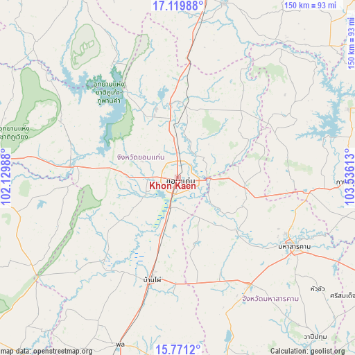
Khon Kaen GPS coordinates[2]
16° 26' 48.156" North, 102° 49' 58.8" East
| Map corner | latitude | longitude |
|---|---|---|
| Upper-left | 17.11988°, | 102.12988° |
| Center: | 16.44671°, | 102.833° |
| Lower-right: | 15.7712°, | 103.53613° |
| Map W x H: | 150×150 km | = 93.2×93.2mi |
| max Lat: | 20.43353° ⇑28.6% North |
| Khon Kaen: | 16.44671° |
| min Lat: | ⇓71.4% South 5.77434° |
| min Long | Khon Kaen | max Long |
| 97.93288° | 102.833° | 105.49506° |
| W 77.2%⇐ | ⇒22.8% E |
Elevation
Elevation of Khon Kaen is 167 m = 548 ft, and this is 41.5 m = 136 ft above average elevation for this country.
| Max E: |
1011 m = 3317 ft | 31% |
| Khon Kaen | 167 m 548 ft | |
| Avg. | 125.5 m = 412 ft | |
Min E: |
1 m = 3 ft | 69% |
See also: Khon Kaen elevation on elevation.city.
Geographical zone
Khon Kaen is located in North Torrid zone (between Equator and Tropic of Cancer). Distance of this Northern Tropic circle is 777.2 km =482.9 mi to North.| Distance of | km | miles | from Khon Kaen |
|---|---|---|---|
| North Pole | 8178.4 | 5081.8 | to North |
| Arctic Circle | 5572.5 | 3462.6 | to North |
| Tropic Cancer | 777.2 | 482.9 | to North |
| Equator | 1828.7 | 1136.3 | to South |


Nearby cities:
15 places around Khon Kaen: (largest is in red/bold)
• Ban Fang
20.7 km =12.9 mi,  272°
272°
• Ban Haet
28.9 km =18 mi,  195°
195°
• Ban Phai
44.4 km =27.6 mi,  194°
194°
• Chiang Yuen
28.5 km =17.7 mi,  98°
98°
• Chuen Chom
38.6 km =24 mi,  71°
71°
• Huai Mek
45.8 km =28.5 mi, 69°
• Khuean Ubonrat
40.2 km =25 mi,  327°
327°
• Kosum Phisai
33.3 km =20.7 mi,  131°
131°
• Kranuan
39 km =24.2 mi,  42°
42°
• Kut Rang
43.5 km =27 mi,  154°
154°
• Nam Phong
28.5 km =17.7 mi,  4°
4°
• Nong Ruea
42.9 km =26.7 mi,  276°
276°
• Phra Yuen
23.3 km =14.5 mi,  235°
235°
• Sam Sung
28.4 km =17.6 mi, 67°
• Ubonratana
40.2 km =25 mi, 327°
Sources, notices
• [Note1] Compared only with cities in Thailand existing in our database
• [Src1] Map data: © OpenStreetMap contributors (CC-BY-SA)
• [Src2] Other city data from geonames.org with taken over terms of usage.
• [Src3] Geographical zone / Annual Mean Temperature by Robert A. Rohde @ Wikipedia
