Nam Phong geodata
Nam Phong (Khon Kaen) is a seat of a second-order administrative division; located in Thailand in Asia/Bangkok (GMT+7) time zone. In our database, there are 331 cities with bigger population. Compared to other cities in Thailand, 74.7% of cities are located further ↓South; 77.5% of cities are located further ←West and 71.1% of cities have lower elevation than Nam Phong. Note1


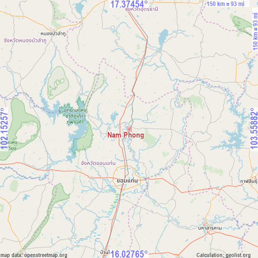
Nam Phong GPS coordinates[2]
16° 42' 8.208" North, 102° 51' 20.484" East
| Map corner | latitude | longitude |
|---|---|---|
| Upper-left | 17.37454°, | 102.15257° |
| Center: | 16.70228°, | 102.85569° |
| Lower-right: | 16.02765°, | 103.55882° |
| Map W x H: | 149.8×149.8 km | = 93.1×93.1mi |
| max Lat: | 20.43353° ⇑25.3% North |
| Nam Phong: | 16.70228° |
| min Lat: | ⇓74.7% South 5.77434° |
| min Long | Nam Phong | max Long |
| 97.93288° | 102.85569° | 105.49506° |
| W 77.5%⇐ | ⇒22.5% E |
Elevation
Elevation of Nam Phong is 172 m = 564 ft, and this is 46.5 m = 153 ft above average elevation for this country.
| Max E: |
1011 m = 3317 ft | 28.9% |
| Nam Phong | 172 m 564 ft | |
| Avg. | 125.5 m = 412 ft | |
Min E: |
1 m = 3 ft | 71.1% |
See also: Thailand elevation on elevation.city.
Geographical zone
Nam Phong is located in North Torrid zone (between Equator and Tropic of Cancer). Distance of this Northern Tropic circle is 748.8 km =465.3 mi to North.| Distance of | km | miles | from Nam Phong |
|---|---|---|---|
| North Pole | 8149.9 | 5064.1 | to North |
| Arctic Circle | 5544.1 | 3444.9 | to North |
| Tropic Cancer | 748.8 | 465.3 | to North |
| Equator | 1857.1 | 1153.9 | to South |


Nearby cities:
15 places around Nam Phong: (largest is in red/bold)
• Ban Fang
36.1 km =22.4 mi,  219°
219°
• Chiang Yuen
41.5 km =25.8 mi,  141°
141°
• Chuen Chom
37.9 km =23.5 mi,  115°
115°
• Huai Mek
42.3 km =26.3 mi,  107°
107°
• Khon Kaen
28.5 km =17.7 mi,  184°
184°
• Khuean Ubonrat
24.4 km =15.2 mi,  283°
283°
• Kranuan
23.8 km =14.8 mi,  88°
88°
• Kumphawapi
48.3 km =30 mi,  20°
20°
• Non Sa-at
31 km =19.3 mi,  7°
7°
• Non Sang
35.9 km =22.3 mi,  301°
301°
• Nong Kung Si
47.7 km =29.6 mi,  97°
97°
• Phra Yuen
46.8 km =29.1 mi,  207°
207°
• Sam Sung
29.7 km =18.5 mi,  126°
126°
• Si That
48.8 km =30.3 mi,  51°
51°
• Ubonratana
24.4 km =15.2 mi, 283°
Sources, notices
• [Note1] Compared only with cities in Thailand existing in our database
• [Src1] Map data: © OpenStreetMap contributors (CC-BY-SA)
• [Src2] Other city data from geonames.org with taken over terms of usage.
• [Src3] Geographical zone / Annual Mean Temperature by Robert A. Rohde @ Wikipedia
