Huai Mek geodata
Huai Mek (Kalasin) is a seat of a second-order administrative division; located in Thailand in Asia/Bangkok (GMT+7) time zone. With population of 12,352 people, there are 259 cities with bigger population in this country. Compared to other cities in Thailand, 73.4% of cities are located further ↓South; 82.1% of cities are located further ←West and 74.3% of cities have lower elevation than Huai Mek. Note1


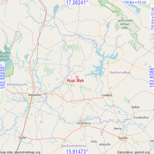
Huai Mek GPS coordinates[2]
16° 35' 23.1" North, 103° 14' 7.692" East
| Map corner | latitude | longitude |
|---|---|---|
| Upper-left | 17.26241°, | 102.53235° |
| Center: | 16.58975°, | 103.23547° |
| Lower-right: | 15.91473°, | 103.9386° |
| Map W x H: | 149.8×149.9 km | = 93.1×93.1mi |
| max Lat: | 20.43353° ⇑26.6% North |
| Huai Mek: | 16.58975° |
| min Lat: | ⇓73.4% South 5.77434° |
| min Long | Huai Mek | max Long |
| 97.93288° | 103.23547° | 105.49506° |
| W 82.1%⇐ | ⇒17.9% E |
Elevation
Elevation of Huai Mek is 181 m = 594 ft, and this is 55.5 m = 182 ft above average elevation for this country.
| Max E: |
1011 m = 3317 ft | 25.7% |
| Huai Mek | 181 m 594 ft | |
| Avg. | 125.5 m = 412 ft | |
Min E: |
1 m = 3 ft | 74.3% |
See also: Thailand elevation on elevation.city.
Geographical zone
Huai Mek is located in North Torrid zone (between Equator and Tropic of Cancer). Distance of this Northern Tropic circle is 761.3 km =473 mi to North.| Distance of | km | miles | from Huai Mek |
|---|---|---|---|
| North Pole | 8162.5 | 5071.9 | to North |
| Arctic Circle | 5556.6 | 3452.7 | to North |
| Tropic Cancer | 761.3 | 473 | to North |
| Equator | 1844.6 | 1146.2 | to South |


Nearby cities:
15 places around Huai Mek: (largest is in red/bold)
• Chiang Yuen
24.8 km =15.4 mi,  216°
216°
• Chuen Chom
7.4 km =4.6 mi,  238°
238°
• Kalasin
33.8 km =21 mi,  121°
121°
• Kantharawichai
30 km =18.6 mi,  167°
167°
• Khong Chai
43.7 km =27.2 mi,  147°
147°
• Kosum Phisai
42 km =26.1 mi,  205°
205°
• Kranuan
21.2 km =13.2 mi,  307°
307°
• Nam Phong
42.3 km =26.3 mi,  287°
287°
• Nong Kung Si
9.6 km =6 mi,  45°
45°
• Sahatsakhan
33.3 km =20.7 mi,  65°
65°
• Sam Chai
44.5 km =27.7 mi, 46°
• Sam Sung
17.4 km =10.8 mi,  252°
252°
• Si That
42.7 km =26.5 mi,  357°
357°
• Tha Khantho
38.9 km =24.2 mi,  1°
1°
• Yang Talat
25.4 km =15.8 mi, 146°
Sources, notices
• [Note1] Compared only with cities in Thailand existing in our database
• [Src1] Map data: © OpenStreetMap contributors (CC-BY-SA)
• [Src2] Other city data from geonames.org with taken over terms of usage.
• [Src3] Geographical zone / Annual Mean Temperature by Robert A. Rohde @ Wikipedia
